Moel Hebog, Moel yr Ogof and Moel Lefn
A moderate walk (mountain (above 600m)) in national park Snowdonia in Gwynedd, Wales, about 9.50km (5.90 mi) long with an estimated walking time of about 4:30h. It is unsuitable for families with children, prams & pushchairs, wheelchairs.
Elevation Profile
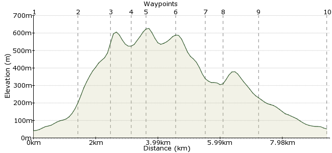
Ascent
635m (2083ft)
Descent
625m (2050ft)
Max. Elevation
630m (2066ft)
Altitude Gain & Loss
1260m (4133ft)
Start & End
Beddgelert bus stop
Distance
9.50km
(5.9mi)
(5.9mi)
Duration
~4:30h
Difficulty
Moderate
Ordnance Survey Map
It’s easy to overlook the three peaks that rise up behind Beddgelert. Tucked between the famous Snowdon range and the distinctive Nantlle Ridge, Moel Hebog, Moel yr Ogof and Moel Lefn are not on everyone’s Snowdonia hit list. But traversing these hills provides a day of simple scrambling, hidden caves and some challenging navigation through the Beddgelert Forest.
The route starts and finishes in Beddgelert, which can be reached easily using the Snowdon Sherpa bus network.
Walk Functions
Share
Nearby Walks
Exploring the history around Beddgelert
A leisurely, circular walk (low hills and fells (below 600m)) starting in Gwynedd, Wales, about 7.60km (4.72 mi) long, duration: ~2:45h.Snowdon traverse - South to North
A moderate, linear walk (mountain (above 600m)) starting in Gwynedd, Wales, about 15.30km (9.51 mi) long, duration: ~7:15h.Snowdon's southern ridge
A moderate, circular walk (mountain (above 600m)) starting in Gwynedd, Wales, about 10.80km (6.71 mi) long, duration: ~5:45h.Walk Map
- $walk->POI array(0)
Waypoints
OS Grid SH589480
From the bus stop outside The Tanronnen Inn, follow the road away from the river. Just past the church, a footpath begins where the road bends. As you head round to the right, the path crosses a newly constructed section of the Welsh Highland Railway.
OS Grid SH575478
Past the railway, an obvious path ascends the shoulder of Moel Hebog that rises up from Cwm Bleiddiaid and Cwm Llwy. As you climb the slope, the imposing Y Diffwys cliff dominates the view.
About 1.49 km (~0.93 miles) from 
OS Grid SH567474
Just below the high point of the Y Diffwys cliff, the path veers left on to a slope of loose scree, where some easy scrambling brings you onto the top of Moel Hebog.
About 0.94 km (~0.58 miles) from 
OS Grid SH561476
The dry stone wall heading northwest from the summit provides a useful handrail to Moel yr Ogof. Near Bwlch Meillionen, you pass through a 10-metre wide cleft in the rock.
About 0.63 km (~0.39 miles) from 
OS Grid SH557478
Among the rocks and boulders near the summit of Moel yr Ogof, look for Ogof Owain Glyndwr, a cave named after Owain Glyndwr, who used it as a hiding place. The entrance to the cave is to the right of the summit as you approach from Moel Hebog, but be warned – a lot of people fail to find it!
About 0.45 km (~0.28 miles) from 
OS Grid SH554485
From Moel yr Ogof, follow the crest of the hill to the summit of Moel Lefn, the shortest of the three hills at 638m. From here, there are no clear paths down and navigation requires some care.
About 0.85 km (~0.53 miles) from 
OS Grid SH554496
As you head towards Bwlch Cwm-trwsgl, look out for another hidden cave shaft, surrounded by mosses and ferns – it’s just near to the stone wall you cross to reach the Bwlch.
About 1.00 km (~0.62 miles) from 
OS Grid SH558497
The walk through the Beddgelert Forest can be tricky. Although the first section through the forest is signposted, it requires concentration – leaving the path could lead to several hours of wandering about. Blue wooden posts mark the way across a cleared section, then the path re-enters the forest.
About 0.41 km (~0.25 miles) from 
OS Grid SH567489
The final section of the route follows a bridleway through woodland and farmland, before rejoining the path you came in on near the new railway.
About 1.17 km (~0.73 miles) from 
 Back in Beddgelert
OS Grid SH587482
Head back into Beddgelert, where there is a healthy selection of cafés and pubs while you wait for the Snowdon Sherpa bus back home.
About 2.14 km (~1.33 miles) from 
