The view from afar - Moel Eilio and Snowdon's outliers
A moderate walk (mountain (above 600m)) in national park Snowdonia in Gwynedd, Wales, about 11.40km (7.08 mi) long with an estimated walking time of about 5:00h. It is unsuitable for families with children, prams & pushchairs, wheelchairs.
Elevation Profile
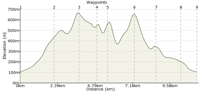
Ascent
635m (2083ft)
Descent
633m (2076ft)
Max. Elevation
670m (2198ft)
Altitude Gain & Loss
1268m (4159ft)
Start & End
Llanberis
Distance
11.40km
(7.08mi)
(7.08mi)
Duration
~5:00h
Difficulty
Moderate
Ordnance Survey Map
Snowdon is a fine looking mountain, standing proud among the surrounding peaks. To best appreciate the scale and shape of Wales' highest summit, you need to see it from a nearby vantage point. This walk takes you over three of Snowdon's outlying peaks with some of the best views you will find. It's no short stroll either - a climb of nearly 600m from Llanberis to Moel Eilio. The walk starts and finishes in Llanberis, which can be reached via the Snowdon Sherpa bus network.
Walk Functions
Share
Nearby Walks
Llyn Padarn
A leisurely, circular walk (countryside) starting in Clwyd, Wales, about 7.70km (4.78 mi) long, duration: ~2:30h.Y Garn and The Devil's Kitchen
A leisurely, circular walk (mountain (above 600m)) starting in Clwyd, Wales, about 6.40km (3.98 mi) long, duration: ~3:30h.The Rhyd-Ddu path up Snowdon
A moderate, circular walk (mountain (above 600m)) starting in Gwynedd, Wales, about 12.00km (7.46 mi) long, duration: ~6:00h.Walk Map
- $walk->POI array(0)
Waypoints
OS Grid SH578603
From the centre of Llanberis, follow signs to the Youth Hostel. Carry on past the hostel for about 300m, then take the footpath heading onto the steep ground.
OS Grid SH566586
Once out onto clear ground, the route is simple as it follows the line of the hill. You will pass two ancient hut circles on the way, with great views of the cliffs between Moel Eilio and Foel Gron.
About 2.16 km (~1.34 miles) from 
OS Grid SH555573
The summit! Climbing over, it's now a classic hilltop walk, with views across to Cwm Clogwyn and Yr Wyddfa, the peak more commonly known as Snowdon (outside Wales at least).
About 1.59 km (~0.99 miles) from 
OS Grid SH564566
From Moel Eilio, stick to the ridge above Cwm Dwythwch to Foel Gron.
About 1.14 km (~0.71 miles) from 
OS Grid SH570563
Stay on the ridge to Foel Goch. This is where you will get the best views of Snowdon; look for the Snowdon Ranger Path winding its way towards the Clogwyn Du'r Arddu ridge. From the summit, drop down the steep slope into the valley.
About 0.63 km (~0.39 miles) from 
OS Grid SH586564
From the valley, there is a bridleway heading back to Llanberis, but it would be rude to leave out the last summit this side of Snowdon. It's an easy climb up to Moel Cynghorion, where you can watch the crowds trudge up the Llanberis path or taking the easy option on the train.
About 1.64 km (~1.02 miles) from 
OS Grid SH578573
You'll need to pick your way down from the summit, taking care through the outcrops into the Maesgwyn valley where you can pick up the bridleway.
About 1.21 km (~0.75 miles) from 
OS Grid SH579588
The bridleway crosses the Snowdon railway as it makes its way back to LLanberis.
About 1.60 km (~0.99 miles) from 
 Llanberis again
OS Grid SH579599
Back into town, where you can take your pick of walker-friendly pubs and cafes; Pete's Eats is the most popular spot for outdoors types, right in the town centre.
About 1.08 km (~0.67 miles) from 
