History in the hills of Conwy
A moderate walk (low hills and fells (below 600m)) in national park Snowdonia starting and finishing in Clwyd, Wales, about 12.30km (7.64 mi) long with an estimated walking time of about 5:00h. It is unsuitable for families with children, prams & pushchairs, wheelchairs.
Elevation Profile
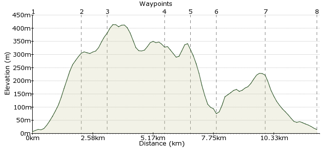
Ascent
534m (1751ft)
Descent
527m (1729ft)
Max. Elevation
420m (1377ft)
Altitude Gain & Loss
1061m (3480ft)
Start
Llanfairfechan
End
Conwy
Distance
12.30km
(7.64mi)
(7.64mi)
Duration
~5:00h
Difficulty
Moderate
Ordnance Survey Maps
Most car-free walkers heading to Snowdonia change at Llandudno Junction and go straight for the famous peaks of Snowdon, Tryfan and their chums. But it's worth taking a day to explore the hills between Llanfairfechan and Conwy. Smaller than their southern cousins they may be, but nothing beats a hill walk with a sea view.
This walk starts and finishes at stations on the line between Llandudno and Bangor. They are request stops, so make sure you tell the guard where you are getting off.
Walk Functions
Share
Nearby Walks
Llanfairfechan
A leisurely, circular walk (coast) starting in Clwyd, Wales, about 5.60km (3.48 mi) long, duration: ~1:45h.Llanfairfechan to Penrhyn Castle
A moderate, linear walk (coast) starting in Clwyd, Wales, about 10.10km (6.28 mi) long, duration: ~3:00h.Aber Falls
A leisurely, circular walk (riverside) starting in Clwyd, Wales, about 1.80km (1.12 mi) long, duration: ~0:30h.Walk Map
- $walk->POI array(0)
Waypoints
OS Grid SH677752
From the station, head into the town centre. At the crossroads, cross over and walk up Village Road. The road turns right; cross the bridge and head into Bryn Road. Keep heading uphill until the town becomes countryside.
OS Grid SH699749
Take the footpath that leads to the Penmaen Mawr quarry - one of the few still in use in this part of Wales. It mainly produces aggregate for road building and railways.
About 2.13 km (~1.32 miles) from 
OS Grid SH709747
This section passes some of the history of the region - the Neolithic stone circles and hut circles. There are some fantastic examples still standing, which you will pass along the route to Ffridd Wanc, including the site of a Neolithic axe factory on Graiglwyd hill.
About 1.02 km (~0.63 miles) from 
OS Grid SH732752
The route joins the North Wales path for a short section. Just past Craig Hafodwen, take the footpath to Foel Lus.
About 2.35 km (~1.46 miles) from 
OS Grid SH732762
The summit of this hill has great views of the North Wales coastline and out to Conwy Bay. Mmm, lovely fresh air! Drop down towards the sea and join the path heading towards Capelulo.
About 1.06 km (~0.66 miles) from 
OS Grid SH744766
Drop into the village, then take the footpath past the woods towards Alltwen. Follow round the southern side of the hill until you find the path heading up to the top. Lots of ups and downs today! Head back down the way you came to rejoin the North Wales Path.
About 1.16 km (~0.72 miles) from 
OS Grid SH759777
The path leads to Mynydd Dref, also known as Conwy Mountain, but it's polite to use the local names, don't you agree? This is the hill you can see from Llandudno Junction as you look west along the platforms.
About 1.95 km (~1.21 miles) from 
 Conwy
ConwyOS Grid SH781775
The path from Mynydd Dref heads straight into Conwy. The station is near the town centre, and there are bus services from here too. If you have time, head to the Afon Conwy estuary for a look at Conwy Castle.
About 2.24 km (~1.39 miles) from 
