Whernside - one of Yorkshire's Big Three
A moderate walk (mountain (above 600m)) in national park Yorkshire Dales starting and finishing in North Yorkshire, England, about 14.50km (9.01 mi) long with an estimated walking time of about 5:45h. It is unsuitable for families with children, prams & pushchairs, wheelchairs.
Elevation Profile
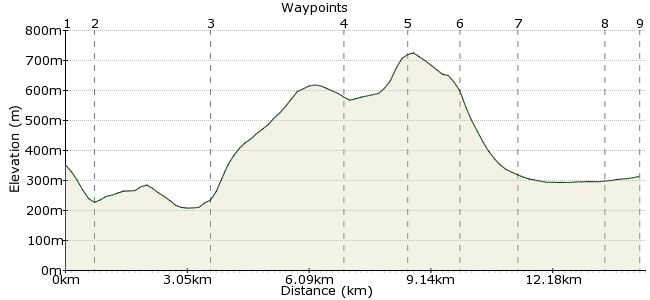
Ascent
513m (1683ft)
Descent
550m (1804ft)
Max. Elevation
730m (2395ft)
Altitude Gain & Loss
1063m (3487ft)
Start
Dent Station
End
Ribblehead Station
Distance
14.50km
(9.01mi)
(9.01mi)
Duration
~5:45h
Difficulty
Moderate
Ordnance Survey Map
Whernside is one of Yorkshire's Three Peaks, along with Ingleborough and Pen-y-ghent. It's a fine walking day out and, thanks to the Settle-Carlisle railway, you can go up one side and down the other - surely the best way to tackle any mountain! This walk starts at tiny Dent station - the highest mainline station in England - and finishes by heading underneath the spectacular Ribblehead viaduct. The Dalesbus also runs to both stations: www.dalesbus.org
Walk Functions
Share
Nearby Walks
Dent to Ribblehead via Great Knoutberry Hill
A moderate, linear walk (mountain (above 600m)) starting in Cumbria, England, about 15.00km (9.32 mi) long, duration: ~6:00h.Rise Hill from Dent
A moderate, circular walk (low hills and fells (below 600m)) starting in Cumbria, England, about 16.50km (10.25 mi) long, duration: ~6:15h.Garsdale circular to Great Shunner Fell summit
A strenuous, circular walk (mountain (above 600m)) starting in Cumbria, England, about 22.30km (13.86 mi) long, duration: ~8:45h.Walk Map
- $walk->POI array(0)
Waypoints
OS Grid SD763874
Is there a finer place to start a car-free walk than Dent station? Nestled deep in Dentdale, it is right in the heart of some wonderful scenery. You can even stay here: www.dentstation.co.uk for more details. From the staion, follow Coal Road downhill into Dentdale.
OS Grid SD760867
Cross the bridge over the River Dee and pick up the Dales Way heading west.
About 0.76 km (~0.47 miles) from 
OS Grid SD734857
At Laithbank, leave the Dales Way and pick up the footpath heading uphill on to the northern slopes of Whernside. This soon joins a bridleway that contours round to the eastern side of Whernside.
About 2.87 km (~1.78 miles) from 
OS Grid SD747826
Veer off the bridleway onto the track which heads on to the flattish summit of Whernside. Cross the wall and use it to lead you on to the summit.
About 3.36 km (~2.09 miles) from 
OS Grid SD737814
The top! At 736m, it just pips Pen-y-ghent and Ingleborough as the highest point in Yorkshire. Continue along the path onto the southern slope.
About 1.58 km (~0.98 miles) from 
OS Grid SD734802
Just below Low Pike, a path heads sharply down the eastern slope of Whernside towards the hamlet of Bruntscar.
About 1.14 km (~0.71 miles) from 
OS Grid SD737788
Pick up the bridleway heading northeast from Bruntscar. At Ivescar, take the footpath that heads east, towards the imposing spectacle of the Ribblehead Viaduct.
About 1.43 km (~0.89 miles) from 
OS Grid SD759795
This fine structure - 24 arches that reach 32m high and span 402m across - is a great finish to the walk. Hopefully the sun will be setting as you walk underneath it, for the perfect photo of Whernside back through the arches.
About 2.18 km (~1.35 miles) from 
 Ribblehead station
OS Grid SD765789
From the viaduct, it's a short trot to the station. And should you have to wait for a train, the nearby Station Inn is the perfect place to while away the time...
About 0.85 km (~0.53 miles) from 
