Mawddach Trail
A moderate walk (riverside) in national park Snowdonia starting and finishing in Gwynedd, Wales, about 12.40km (7.71 mi) long with an estimated walking time of about 3:30h. It is suitable for prams & pushchairs, wheelchairs, but unsuitable for families with children.
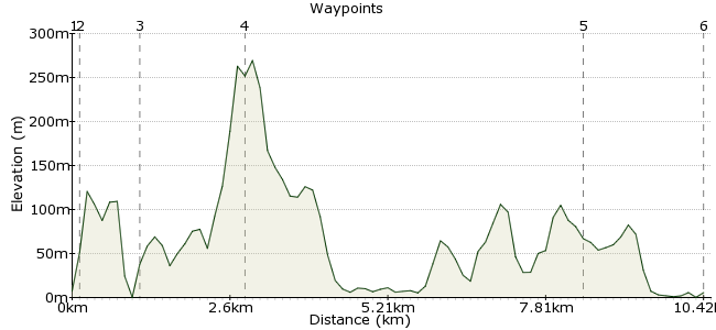
Elevation Profile
Ascent
18m (59ft)
Descent
25m (82ft)
Max. Elevation
270m (885ft)
Altitude Gain & Loss
43m (141ft)
Start
Barmouth Station
End
Arthog
Distance
12.40km
(7.71mi)
(7.71mi)
Duration
~3:30h
Difficulty
Moderate
The Mawddach Trail multi-use path winds its way for 15 km (9.5 miles) along the disused railway track on the southern edge of the Mawddach estuary, starting at the picturesque market town of Dolgellau and finishing by crossing the iconic railway bridge over the mouth of the estuary into Barmouth. The flat trail-bed makes this route suitable to a wide vaiety of users. Further information and guide book available at www.MawddachTrail.co.uk
Walk Functions
Share
Nearby Walks
Cader Idris from Dolgellau
A moderate, circular walk (mountain (above 600m)) starting in Gwynedd, Wales, about 15.30km (9.51 mi) long, duration: ~7:00h.The Mawddach Trail from Dolgellau
A strenuous, circular walk (low hills and fells (below 600m)) starting in Gwynedd, Wales, about 21.70km (13.48 mi) long, duration: ~7:15h.Y Garn from Llanelltyd
A moderate, linear walk (mountain (above 600m)) starting in Gwynedd, Wales, about 10.70km (6.65 mi) long, duration: ~4:45h.Walk Map
- $walk->POI array(0)
Waypoints
OS Grid SH727179
The trail starts by the river Wynion at the Marian car-park, adjacedt to the Bont Fawr (big bridge)
OS Grid SH725180
The trail starts by the river Wynion at the Marian car-park, adjacedt to the Bont Fawr (big bridge)
About 0.20 km (~0.12 miles) from 
OS Grid SH714182
Cross the road heading slightly to the right to pick up the trail as it passes through another small car-park
About 1.12 km (~0.7 miles) from 
OS Grid SH694184
Cross the carpark, pass the front of the George III (if you can resist not stopping for a pint) and follow the road to the gate and beyond
About 1.97 km (~1.22 miles) from 
OS Grid SH640147
Road crossing
About 6.57 km (~4.08 miles) from 
 End of Barmouth Bridge
OS Grid SH618154
Junction with busy A496. Turn Left and head into town
About 2.34 km (~1.45 miles) from 
