The Forest of Bowland
A strenuous walk (moorland) in Lancashire, England, about 23.00km (14.29 mi) long with an estimated walking time of about 7:30h. It is unsuitable for families with children, prams & pushchairs, wheelchairs.
Elevation Profile
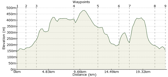
Ascent
276m (905ft)
Descent
268m (879ft)
Max. Elevation
480m (1574ft)
Altitude Gain & Loss
544m (1784ft)
Start & End
Slaidburn
Distance
23.00km
(14.29mi)
(14.29mi)
Duration
~7:30h
Difficulty
Strenuous
Ordnance Survey Map
The Forest of Bowland is a wild, lonely expanse of moorland where you can wander for many a happy mile without any disturbance. Much of the region is tricky to reach by public transport, but the effort is definitely worthwhile. The easiest place from which to explore is Slaidburn, which has regular buses from Settle.
Walk Functions
Share
Nearby Walks
A walk around Whitendale
A moderate, circular walk (low hills and fells (below 600m)) starting in Lancashire, England, about 15.90km (9.88 mi) long, duration: ~5:30h.Cross O'Greet to Bowland Knotts Circular
A leisurely, walk (countryside) starting in Lancs, England, about 9.70km (6.03 mi) long, duration: ~4:15h.Giggleswick/Settle Circular
A moderate, circular walk (countryside) starting in North Yorkshire, England, about 12.70km (7.89 mi) long, duration: ~4:00h.Walk Map
- $walk->POI array(0)
Waypoints
OS Grid SD712524
Brass band players will know Slaidburn as a classic brass tune. For the rest of us, it's the start of a great day out. There is a Youth Hostel here if you want to do a bit more exploring of the region.
OS Grid SD701535
From Slaidburn, head northwest towards the hamlet of Myttons. From here, follow House Lane northwest.
About 1.54 km (~0.96 miles) from 
OS Grid SD694549
Just beyond Higher Wood House is the start of the Hornby Track, a roman road across the moor. Continue on to Croasdale Fell - this is right in the heart of the Lancashire Moors.
About 1.55 km (~0.96 miles) from 
OS Grid SD653587
Just past the high point of the track is a permitted footpath which heads southwest past Esp Crag. Follow this on to Wolfhole Crag, one of the high points of the moor at 527m.
About 5.58 km (~3.47 miles) from 
OS Grid SD631557
from Wolfhole, descend via the southern side into Black Dell. It's a wet and boggy mire, so make sure you have taken a bearing! Easy to get lost around these parts...
About 3.71 km (~2.31 miles) from 
OS Grid SD653535
Follow the Brennand River that flows along Black Dell until you reach Whin Fell. Cross the river to the path that runs northeast alongside the coniferous plantation.
About 3.14 km (~1.95 miles) from 
OS Grid SD660549
At Whitendale, the footpath meets a bridleway. Follow this east over Dunsop Fell. Where the bridleway forks, take the southern line.
About 1.53 km (~0.95 miles) from 
OS Grid SD694531
The bridleway meets a minor road that takes you through Parrock Head and back to Slaidburn.
About 3.84 km (~2.39 miles) from 
 Back to Slaidburn
OS Grid SD709524
It may be small, but it's got the essentials...an overnight stay in Slaidburn is worthwhile as it will give you a taste of the moor by night. And, of course, there is a pub - The Hark To Bounty, where you can reflect on the day over a frothing pint.
About 1.68 km (~1.04 miles) from 
