Lad Law from Trawden
A moderate walk (low hills and fells (below 600m)) in Lancashire, England, about 9.80km (6.09 mi) long with an estimated walking time of about 3:45h. It is unsuitable for families with children, prams & pushchairs, wheelchairs.
Elevation Profile
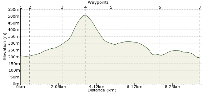
Ascent
306m (1003ft)
Descent
315m (1033ft)
Max. Elevation
510m (1673ft)
Altitude Gain & Loss
621m (2036ft)
Start & End
Trawden
Distance
9.80km
(6.09mi)
(6.09mi)
Duration
~3:45h
Difficulty
Moderate
Ordnance Survey Map
This short walk in the South Pennines is a great half day out - perfect for stretching the legs before a longer walk across the moors. It's popular walking country, too - the route crosses the Pendle Way and the Pennine Way is not too far east. Start from Trawden, which has good bus links to nearby towns.
Walk Functions
Share
Nearby Walks
Pendle Hill
A leisurely, circular walk (low hills and fells (below 600m)) starting in Lancashire, England, about 8.50km (5.28 mi) long, duration: ~3:15h.Haworth to Hebden Bridge
A moderate, linear walk (moorland) starting in West Yorkshire, England, about 13.80km (8.57 mi) long, duration: ~5:00h.Hebden Bridge Birthday Walk
A moderate, circular walk (countryside) starting in West Yorkshire, England, about 12.40km (7.71 mi) long, duration: ~4:15h.Walk Map
- $walk->POI array(0)
Waypoints
OS Grid SD911385
At the church in Trawden, walk along the road heading southeast - Lad Law rises up straight ahead as a useful check that you are heading the right way!
OS Grid SD915381
Just before Hollin Hall, a footpath leaves the southern side of the road. Follow this to the woody section near Gilford Clough.
About 0.42 km (~0.26 miles) from 
OS Grid SD921366
Cross the Pendle Way and take the permitted footpath on to Lad Law. Be warned - it's a pretty steep climb!
About 1.71 km (~1.06 miles) from 
OS Grid SD929356
Lad Law is the summit of Boulsworth Hill, 517m high. Despite being so close to the mill towns of Lancashire, it feels a long way from anywhere up here.
About 1.28 km (~0.8 miles) from 
OS Grid SD927368
Follow the permitted footpath down again from the summit, and rejoin the Pendle Way near Spoutley Lumb. You can return directly to Trawden, but a more enjoyable option is to follow the Pendle Way a short distance to Turnhole Clough.
About 1.31 km (~0.81 miles) from 
OS Grid SD933393
At Turnhole Clough, turn off for the village of Wycoller. From here, it's a short trek across the fields back to Trawden.
About 2.57 km (~1.6 miles) from 
 Back to Trawden
OS Grid SD912385
Catch the bus back from Trawden. The pub of choice is the Trawden Arms on Church Street.
About 2.19 km (~1.36 miles) from 
