The Cheviot
A strenuous walk (mountain (above 600m)) in Roxburghshire, Scotland, about 29.90km (18.58 mi) long with an estimated walking time of about 11:15h (1 overnight stay). It is unsuitable for families with children, prams & pushchairs, wheelchairs.
Elevation Profile
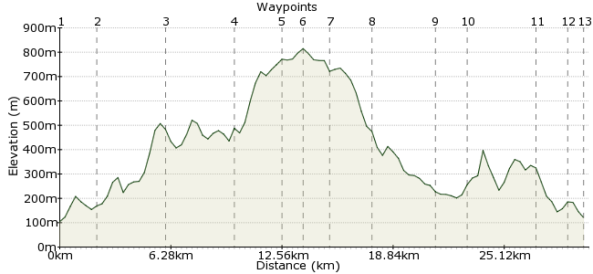
Ascent
832m (2729ft)
Descent
816m (2677ft)
Max. Elevation
820m (2690ft)
Altitude Gain & Loss
1648m (5406ft)
Start & End
Kirk Yetholm
Distance
29.90km
(18.58mi)
(18.58mi)
Duration
~11:15h
Difficulty
Strenuous
Ordnance Survey Map
The Cheviots Hills are the main attraction of the Northumberland National Park. They are as wild and remote as walking gets in England, and all the better for it. A walk to the highest point, The Cheviot, from Kirk Yetholm is a long but rewarding day out. Much of the route follows the Pennine Way, which is a badge of honour for any walk. Kirk Yetholm, across the border in Scotland has regular buses from the surrounding towns, and plenty of accommodation including a Youth Hostel.
Walk Functions
Share
Nearby Walks
The lower tors of the Cheviots
A moderate, circular walk (low hills and fells (below 600m)) starting in Northumberland, England, about 18.90km (11.74 mi) long, duration: ~7:00h.Walk to Holy Island
A moderate, circular walk (coast) starting in Northumberland, England, about 19.40km (12.05 mi) long, duration: ~5:45h.Berwick-Upon-Tweed to Eyemouth
A moderate, linear walk (coast) starting in Northumberland, England, about 14.30km (8.89 mi) long, duration: ~4:15h.Walk Map
- $walk->POI array(0)
Waypoints
OS Grid NT825283
Start from the town of Kirk Yetholm. Given the length of this walk, you may want to stay the night before to get an early start. It's a pleasant little town, so worth making a weekend of it! The start is easy to find - pick up the Pennine Way heading south.
OS Grid NT842271
A short way from Kirk Yetholm, the Pennine Way splits in two for a short section. The left-hand fork takes you over White Law, a small hill on the edge of the Cheviots. The right-hand fork takes a lower-level route past Halterburn. It's a great start to the walk either way.
About 2.01 km (~1.25 miles) from 
OS Grid NT858236
The Pennine Way rejoins itself just beneath Black Hag, and, if you avoided White Law, it's the first major climb of the day - The Schil. The summit is uncommon for the Cheviots, with rocky outcrops - perfect for the first cup of tea of the day. For a shorter day out, you can turn back from here.
About 3.84 km (~2.39 miles) from 
OS Grid NT876202
Continue south from The Schil along the Pennine Way. Pass the Mountain Refuge Hut and begin the long climb up to Cairn Hill.
About 3.84 km (~2.39 miles) from 
OS Grid NT904195
Cairn Hill is a just south of The Cheviot, so nearly there! From the summit, stay along the top to The Cheviot.
About 2.88 km (~1.79 miles) from 
OS Grid NT908205
The summit! 815m of grassy roundness in the middle of nowhere. Perfect. From the summit, continue heading northeast before taking the track heading north (about 600m past the summit cairn).
About 1.08 km (~0.67 miles) from 
OS Grid NT901191
The land north of The Cheviot is grouse-shooting land, so no descent that way unfortunately. Instead, retrace your steps to Cairn Hill and back via the Pennine Way. It's worth taking a careful peek into the ravine of Hen Hole; you can follow the steep ground south of the ravine into College Valley.
About 1.49 km (~0.93 miles) from 
OS Grid NT878200
Near the Mountain Refuge hut, take the bridleway heading north through the beautiful College Valley. Drop into the valley via Red Cribs and follow the bridleway north. If you have time, explore the stream coming down from Hen Hole, and the Three Sisters Falls.
About 2.38 km (~1.48 miles) from 
OS Grid NT885234
This is about as quiet as a valley walk gets - enjoy the silence! The coniferous trees here are slowly being replaced with natural woodland, which will soon make the walk even more special.
About 3.41 km (~2.12 miles) from 
OS Grid NT887253
Just beyond an old disused quarry, a footpath leave the bridleway heading northwest. This path takes you through the woodland of Sinkside Hill and back to Kirk Yetholm.
About 1.88 km (~1.17 miles) from 
OS Grid NT852270
The path takes you past the Stob Stanes. These ancient stones are thought to mark the border between Scotland and England (just 200m east), although, as with all these ancient sites, no one really knows, do they.
About 3.88 km (~2.41 miles) from 
OS Grid NT835277
The footpath soon meets both the Pennine Way and the St Cuthbert's Way. Follow these west back to the town.
About 1.80 km (~1.12 miles) from 
 Back to Kirk Yetholm
OS Grid NT827281
Back again, after a very long fay out. Luckily Kirk Yetholm, and nearby Town Yetholm, have a good selection of places to stay and, more importantly, get a drink. It's worth booking ahead for a room, as the town is a regular stop-off on the long distance paths that pass through it.
About 0.92 km (~0.57 miles) from 

5 comments... join the discussion!
Timwoods
Kirk Yetholm is actually in Roxburghshire, Scotland - thanks to Brian for spotting the error! We've corrected it.
Timwoods
Depends how fast you walk! I would estimate 7-8 hours at a good pace for this walk. The walk isn't signposted but there is a clear path all the way. But you will need a map and compass in case of bad weather.
chris
if i start the walk at 7.15am will i be up for 6pm in kirk yethlom and is the walk sign posted
Timwoods
Hi Chris Yes, there and back. It's probably a couple more, as our walk editor slightly underestimates distances. it's a long day out but well worthwhile!
chris
is that 19 miles there and back