The Tintagel coastline
A leisurely walk (coast) starting and finishing in Cornwall, England, about 6.30km (3.91 mi) long with an estimated walking time of about 2:00h. It is unsuitable for families with children, prams & pushchairs, wheelchairs.
Elevation Profile
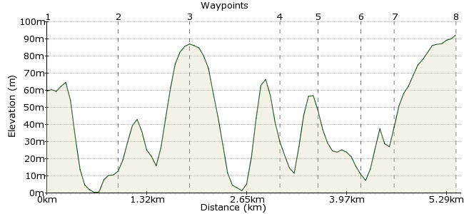
Ascent
99m (324ft)
Descent
66m (216ft)
Max. Elevation
100m (328ft)
Altitude Gain & Loss
165m (540ft)
Start
Boscastle
End
Tintagel
Distance
6.30km
(3.91mi)
(3.91mi)
Duration
~2:00h
Difficulty
Leisurely
Ordnance Survey Map
Stick a pin in a map of Cornwall and you will find a good place to go for a walk. It's a wonderful county, with some of the UK's best coastal walks, and gently rolling farmland along the middle. Even with such fierce competition, the countryside around Tintagel is some of the best. Walking from Boscastle allows you to stretch the legs, before exploring the many sites around Tintagel. Regular buses run between the two towns.
Walk Functions
Share
Nearby Walks
St Nectan's Glen
A leisurely, linear walk (woodland) starting in Cornwall, England, about 4.90km (3.04 mi) long, duration: ~1:30h.Brown Willy and Bodmin Moor from Camelford
A moderate, circular walk (moorland) starting in Cornwall, England, about 15.70km (9.76 mi) long, duration: ~5:15h.The Camel Trail - Wadebridge to Padstow
A leisurely, linear walk (riverside) starting in Cornwall, England, about 8.70km (5.41 mi) long, duration: ~2:30h.Walk Map
- $walk->POI array(0)
Waypoints
OS Grid SX094912
This walk begins in Boscastle, which is served by many buses. It's a traditional fishing village, and start the walk by heading for the picturesque harbour. The land around here is managed by the National Trust.
OS Grid SX084907
Navigation is easy; follow the coast! Head south from the harbour down to Grower Rock. The scenery is magnificent - waves crashing into the rocky cliffs as you wander along the green fields above. Just as Cornwall should be.
About 1.09 km (~0.68 miles) from 
OS Grid SX074903
Several small islands sit just off the coast, with sea birds found all around them.
About 1.06 km (~0.66 miles) from 
OS Grid SX063895
This tiny peninsular sticks out from the coast, and the grassy plateau on top is a great place to have a picnic stop. There are the remains of an iron age castle to explore as well.
About 1.39 km (~0.86 miles) from 
OS Grid SX058892
Follow the path down Smith's Cliff , but stick to the coastline rather than the footpath signposted to Tintagel.
About 0.59 km (~0.37 miles) from 
OS Grid SX053893
This was the first piece of coastline to be purchased by the National Trust, and they still own it today. Great views across th Tintagel Island, if you aren't planning to go to the island itself.
About 0.51 km (~0.32 miles) from 
OS Grid SX050890
This is one of the highlights of the walk - the location of Tintagel Castle, a 13th Century ruin that is said to be the birthplace of King Arthur. The castle is managed by English Heritage, and there is an entrance fee (about £5.00 for adults). Continue onwards into Tintagel Village.
About 0.41 km (~0.25 miles) from 
 Tintagel
OS Grid SX057883
You have three choices here - you can get the bus back to Boscastle (they run about once an hour), return via St Nectan's Glen (a local beauty spot), or walk back along the coast! But make sure you have some fish & chips or an ice cream first.
About 0.93 km (~0.58 miles) from 
