An Old Man's stroll from Coniston
A moderate walk (mountain (above 600m)) in national park Lake District in Cumbria, England, about 10.60km (6.59 mi) long with an estimated walking time of about 5:00h. It is unsuitable for families with children, prams & pushchairs, wheelchairs.
Elevation Profile
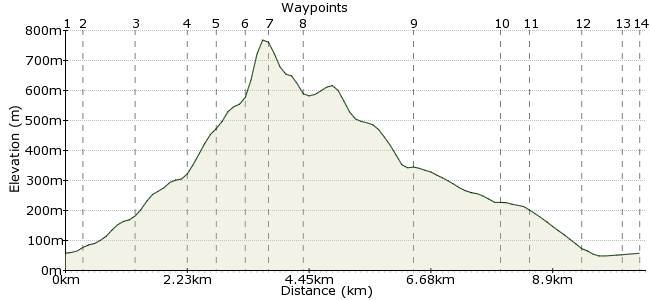
Ascent
704m (2309ft)
Descent
704m (2309ft)
Max. Elevation
770m (2526ft)
Altitude Gain & Loss
1408m (4618ft)
Start & End
Coniston Village Centre
Distance
10.60km
(6.59mi)
(6.59mi)
Duration
~5:00h
Difficulty
Moderate
Ordnance Survey Map
 Car Free Walks TeamCreated by GaryShipp on 16 Feb 2010
This energetic walk takes in one of the Lakes finest summits, with stunning views in all directions.
Walk Functions
Share
Nearby Walks
Coniston to Elterwater via Little Langdale
A leisurely, linear walk (low hills and fells (below 600m)) starting in Cumbria, England, about 9.40km (5.84 mi) long, duration: ~3:30h.Wetherlam
A moderate, linear walk (mountain (above 600m)) starting in Cumbria, England, about 11.30km (7.02 mi) long, duration: ~5:15h.A circular walk around Hawkshead
A moderate, circular walk (woodland) starting in Cumbria, England, about 12.60km (7.83 mi) long, duration: ~4:15h.Walk Map
- $walk->POI array(0)
Waypoints
OS Grid SD303975
This walk starts from the bus stop in the centre of the village. There are a few shops nearby for picking up any last minute treats.
OS Grid SD299976
Leave the village by the marked path.
About 0.34 km (~0.21 miles) from 
OS Grid SD293981
Ignore the 'Miners Bridge' on your right and carry on the track past some small waterfalls to the wall. From here the ascent begins.
About 0.83 km (~0.52 miles) from 
OS Grid SD284980
Straight on here.
About 0.91 km (~0.57 miles) from 
OS Grid SD279980
As you pass here you will see evidence of this valley's industrial past.
About 0.44 km (~0.27 miles) from 
OS Grid SD275982
Quite where this name came from I'm not sure, as the sweat you've worked up will tell you, you're now at 600m elevation and the hardwork's just beginning!
About 0.43 km (~0.27 miles) from 
OS Grid SD271980
At 803m, it may fall short of the higher peaks to the North, but its prime location affords fantastical 360 degree views. Take time to enjoy it.
About 0.45 km (~0.28 miles) from 
OS Grid SD266982
At this point, depending on your energy levels, you can extend the walk to take in the imposing summits of Dow Crag, are you can take the easier option of descending the path to Goats Water.
About 0.55 km (~0.34 miles) from 
OS Grid SD274964
Whichever route choice you opted for previosuly, at this point you join the main track off the hill and head eastwards.
About 1.96 km (~1.22 miles) from 
OS Grid SD289970
Avoid the route march down the road by heading south here along the wall boundary.
About 1.60 km (~0.99 miles) from 
OS Grid SD290965
This path is easily spotted.
About 0.48 km (~0.3 miles) from 
OS Grid SD300968
Cross straight over the road and pick up the path on the other side.
About 1.00 km (~0.62 miles) from 
OS Grid SD305972
Pick up the road and head away from the Lake, back into the village.
About 0.64 km (~0.4 miles) from 
 End of the walk
OS Grid SD303975
Finish back at the bus stop.
About 0.38 km (~0.24 miles) from 
