Roseberry Topping
A leisurely walk (low hills and fells (below 600m)) in national park North York Moors in North Yorkshire, England, about 6.90km (4.29 mi) long with an estimated walking time of about 2:30h. It is unsuitable for families with children, prams & pushchairs, wheelchairs.
Elevation Profile
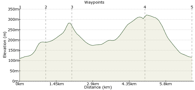
Ascent
192m (629ft)
Descent
186m (610ft)
Max. Elevation
330m (1082ft)
Altitude Gain & Loss
378m (1239ft)
Start & End
Great Ayton
Distance
6.90km
(4.29mi)
(4.29mi)
Duration
~2:30h
Difficulty
Leisurely
Ordnance Survey Map
Great name, great walk. This distinctively shaped hill - the Yorkshire Matterhorn - is a popular favourite on the northern edge of the North York Moors. It's best walked from Great Ayton, which has good bus links and has a station on the Esk Valley line. At only 320m, it's not a taxing climb to the summit, but you'll be rewarded by superb views and some brisk Yorkshire air.
Walk Functions
Share
Nearby Walks
Danby
A leisurely, circular walk (countryside) starting in North Yorkshire, England, about 8.50km (5.28 mi) long, duration: ~2:45h.The Murk Esk in the North York Moors
A leisurely, circular walk (countryside) starting in North Yorkshire, England, about 6.10km (3.79 mi) long, duration: ~2:00h.Helmsley to Wass
A moderate, linear walk (low hills and fells (below 600m)) starting in North Yorkshire, England, about 13.50km (8.39 mi) long, duration: ~4:30h.Walk Map
- $walk->POI array(0)
Waypoints
OS Grid NZ573108
Start in Great Ayton. There are buses, but really the Great Esk Railway is a treat in itself and should be enjoyed as the warm-up to the walk. From the station, you can see the distinctive hill - follow the lane heading northeast.
OS Grid NZ578117
At Aireyholme Farm, look for the footpath leading to Roseberry Topping.
About 1.01 km (~0.63 miles) from 
OS Grid NZ579126
A short scrabble and you're there! Enjoy the fantastic views south across the North York Moors.
About 0.92 km (~0.57 miles) from 
OS Grid NZ593101
For a bit of variety on the way back, follow the path round to the Captain Cook monument, just outside Great Ayton.
About 2.85 km (~1.77 miles) from 
 Back to Great Ayton
OS Grid NZ575107
Follow the path back to the station, and beyond to the village if you need a bus.
About 1.90 km (~1.18 miles) from 

1 comment... join the discussion!
John Patrick
Roseberry Topping's long been a favourite for local family walks and we've done various routes for variety but I've not tried this one so thanks for the suggestion - it's on the schedule for next time :)