Wetherlam
A moderate walk (mountain (above 600m)) in national park Lake District starting and finishing in Cumbria, England, about 11.30km (7.02 mi) long with an estimated walking time of about 5:15h. It is unsuitable for families with children, prams & pushchairs, wheelchairs.
Elevation Profile
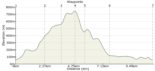
Ascent
689m (2260ft)
Descent
695m (2280ft)
Max. Elevation
750m (2460ft)
Altitude Gain & Loss
1384m (4540ft)
Start
Coniston
End
Skelwith Bridge
Distance
11.30km
(7.02mi)
(7.02mi)
Duration
~5:15h
Difficulty
Moderate
Wetherlam lies north of Coniston village, among the Furness Fells. It's a fine hill, easily the match of its better known neighbour, the Old Man. The best ascent is via Levers Water, which takes you to the saddle between Wetherlam and Swirl How. You can return to Consiton, but for a full day's walk, head north via Wetherlam edge to Little Langdale Tarn and Skelwith Bridge. Both villages have regular bus connections with Ambleside.
Walk Functions
Share
Nearby Walks
Coniston to Elterwater via Little Langdale
A leisurely, linear walk (low hills and fells (below 600m)) starting in Cumbria, England, about 9.40km (5.84 mi) long, duration: ~3:30h.An Old Man's stroll from Coniston
A moderate, circular walk (mountain (above 600m)) starting in Cumbria, England, about 10.60km (6.59 mi) long, duration: ~5:00h.A circular walk around Hawkshead
A moderate, circular walk (woodland) starting in Cumbria, England, about 12.60km (7.83 mi) long, duration: ~4:15h.Walk Map
- $walk->POI array(0)
Waypoints
OS Grid SD301976
Take the bus to Consiton and laugh at all those people trying to find a parking place in a tiny village. Cross the bridge in the village centre and turn right along Station Road. Pick up the footpath at the end, which follows the course of Church Beck.
OS Grid SD283991
A steady climb brings you up to Levers Water. This is a great spot for a coffee from the flask - slap in between Wetherlam and Coniston Old Man.
About 2.39 km (~1.49 miles) from 
OS Grid NY280004
A path winds up on the western side of Black Sails, the middle of three ridges that cascade down from Wetherlam and its neighbours.
About 1.37 km (~0.85 miles) from 
OS Grid NY288010
Upon gaining the saddle, head northeast along Keld Gill Head to Wetherlam. 762m means it isn't a big hitter in the Lakes, but still a classic view.
About 1.02 km (~0.63 miles) from 
OS Grid NY294015
Take a bearing along Wetherlam Edge, and descend carefully. The ground soon becomes less steep, and the path takes you to Greenburn Beck.
About 0.80 km (~0.5 miles) from 
OS Grid NY309029
The path takes you south under Little Langdale Tarn, where in theory you need to switch to OS Map 7 - south east Lakes. However, the navigation is simple - pass through the woodland to pick up the Cumbria Way near Stang End.
About 2.04 km (~1.27 miles) from 
 Skelwith Bridge
OS Grid NY344033
A couple of kms along the Cumbria Way brings you to Skelwith Bridge, where buses will take you up to Ambleside and Grasmere. If you need to wait (or even if you're just a bit parched), the hotel has a good bar.
About 3.43 km (~2.13 miles) from 
