Beinn Eunaich and Beinn a' Chochuill
A moderate walk (mountain (above 600m)) in Argyll and Bute, Scotland, about 15.00km (9.32 mi) long with an estimated walking time of about 7:30h. It is unsuitable for families with children, prams & pushchairs, wheelchairs.
Elevation Profile
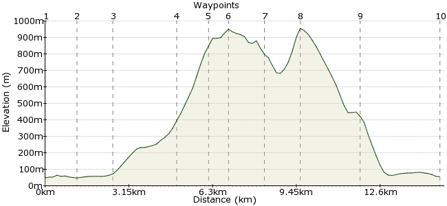
Ascent
1054m (3458ft)
Descent
1046m (3431ft)
Max. Elevation
960m (3149ft)
Altitude Gain & Loss
2100m (6889ft)
Start & End
Loch Awe Station
Distance
15.00km
(9.32mi)
(9.32mi)
Duration
~7:30h
Difficulty
Moderate
Ordnance Survey Maps
The two summits of Beinn Eunaich and Beinn a' Chochuill are connected by a long ridge - meaning plenty of time up among the clouds. A traverse of both peaks makes a rewarding trip from Lochawe. It's a good part of the country for walking, too - Ben Cruachan is one stop along the line. Loch Awe Station is just outside the village of Lochawe, on the northern side of Loch Awe (so easy to find!). Trains running between Oban and Glasgow stop there, and there are a few bus services too
Walk Functions
Share
Nearby Walks
Ben Cruachan
A moderate, circular walk (mountain (above 600m)) starting in Argyll and Bute, Scotland, about 10.60km (6.59 mi) long, duration: ~6:00h.Ben Oss and Beinn Dubhchraig
A moderate, circular walk (mountain (above 600m)) starting in Argyll and Bute, Scotland, about 18.10km (11.25 mi) long, duration: ~8:15h.Ben Lui from Tyndrum
A moderate, circular walk (mountain (above 600m)) starting in Stirlingshire, Scotland, about 15.70km (9.76 mi) long, duration: ~7:00h.Walk Map
- $walk->POI array(0)
Waypoints
OS Grid NN124274
Start at Loch Awe Station. There is a small shop in the village, plus places to stay - check out www.loch-awe.com/main.htm
OS Grid NN132283
A little bit of road walking to start off. Follow the A85 along the loch up to the junction with the B8077. Follow this smaller road up to the river.
About 1.24 km (~0.77 miles) from 
OS Grid NN136295
Just over the bridge, a path leads up to Castles Farm. Just before the farm buildings, take the left fork leading into the valley on the northern side of Allt Mhoille.
About 1.23 km (~0.76 miles) from 
OS Grid NN123315
Follow the track deep into the valley. Just past the Allt Lairig Ianachain, take the path on your right winding up towards the ridge between the two peaks.
About 2.38 km (~1.48 miles) from 
OS Grid NN114325
Once you have reached the ridge, bear due west to the summit of Beinn a' Chochuill.
About 1.30 km (~0.81 miles) from 
OS Grid NN109328
The first summit of the day - which reaches 980m - has terrific views across to the Cruachan Horseshoe. One for another day ...
About 0.65 km (~0.4 miles) from 
OS Grid NN121325
Retrace your steps along the ridge, and head east for Beinn Eunaich.
About 1.30 km (~0.81 miles) from 
OS Grid NN135328
The second Munro of the day is nine metres higher. From the summit, take a bearing for the slope down to Stob Maol, due near south - that's your way down.
About 1.35 km (~0.84 miles) from 
OS Grid NN135305
Follow the line of the ridge and it will bring you back to Castles Farm. From there head back towards Lochawe.
About 2.27 km (~1.41 miles) from 
 Back to Lochawe
OS Grid NN127276
It's a short hop along the road again to Lochawe. The Tight Line pub is a good spot for the post-walk drink - 32 different whiskys! Could be a long night ... they also have a static caravan to hire if you are staying in the area: www.tightlinebar.co.uk
About 2.96 km (~1.84 miles) from 
