Ancient forts on the Dumfries coastline
A leisurely walk (coast) starting and finishing in Dumfries and Galloway, Scotland, about 7.90km (4.91 mi) long with an estimated walking time of about 2:15h. It is unsuitable for families with children, prams & pushchairs, wheelchairs.
Elevation Profile
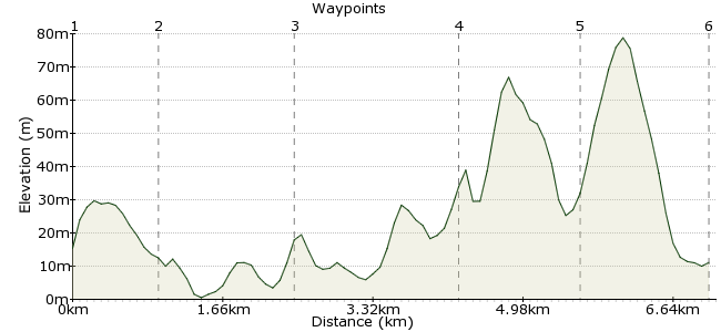
Ascent
20m (65ft)
Descent
24m (78ft)
Max. Elevation
80m (262ft)
Altitude Gain & Loss
44m (143ft)
Start
Kippford
End
Sandyhills
Distance
7.90km
(4.91mi)
(4.91mi)
Duration
~2:15h
Difficulty
Leisurely
Ordnance Survey Map
Scotland's southern coast has some superb coastal walks. This walk takes you past several points of interest, including the curious Mote of Mark. It's the views that are the real star turn, however, especially over Sandyhills Bay. Start at Sandyhills and finish at Kippford; there are five buses a day between the towns, and both also connect to Dalbeattie, which has a few more facilities for a longer stay.
Walk Functions
Share
Nearby Walks
The Wagon Way
A leisurely, circular walk (coast) starting in Cumbria, England, about 4.50km (2.80 mi) long, duration: ~1:15h.Pillar from Ennerale
A hard, circular walk (mountain (above 600m)) starting in Cumbria, England, about 40.00km (24.85 mi) long, duration: ~15:15h.Among the giants - a valley walk in the Lakes
A moderate, linear walk (low hills and fells (below 600m)) starting in Cumbria, England, about 15.40km (9.57 mi) long, duration: ~5:30h.Walk Map
- $walk->POI array(0)
Waypoints
OS Grid NX838545
Start in Kippford, an old ship-building village now popular with yachters. Full name: Kippford or Scaur, Scaur being the nearby village (why 'or' not 'and'?) The village is famous for its sunsets, especially the view over to the hill of Bengairn. Head south through the village along the coast
OS Grid NX845538
After passing through some National Trust land, you reach the Mote of Mark. This is the site of an ancient hillfort dating back to the 5th and 7th centuries - the time of King Arthur!There are good views across to the bird sanctuary of Rough Island, home to oystercatchers and ringed plovers.
About 1.09 km (~0.68 miles) from 
OS Grid NX854523
Continue through the village of Rockcliffe until you reach the site of another ancient fort at Castlehill Point, this time dating to the Iron Age. This area is well known for its butterflies as well.
About 1.67 km (~1.04 miles) from 
OS Grid NX872529
Continue east along the coast, following the clifftop path. Good views over to the Lake District from here.
About 1.92 km (~1.19 miles) from 
OS Grid NX882539
Keep following the coast to reach Portling, another attractive coastal village. Keep heading north to the Needles Eye viewpoint, which has great views across Snadyhills Bay.
About 1.41 km (~0.88 miles) from 
 Sandyhills
OS Grid NX891552
Finish with an ice cream in Snadyhills before catching the bus home.
About 1.58 km (~0.98 miles) from 
