The old line to Threlkeld
A moderate walk (riverside) in national park Lake District in Cumbria, England, about 11.70km (7.27 mi) long with an estimated walking time of about 4:15h. It is unsuitable for families with children, prams & pushchairs, wheelchairs.
Elevation Profile
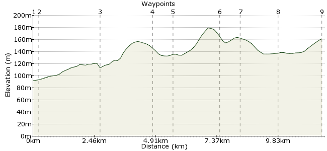
Ascent
302m (990ft)
Descent
293m (961ft)
Max. Elevation
180m (590ft)
Altitude Gain & Loss
595m (1951ft)
Start & End
Keswick
Distance
11.70km
(7.27mi)
(7.27mi)
Duration
~4:15h
Difficulty
Moderate
Dr Beeching maybe something of an enemy of car-free walking, but his closure of many branch lines has at least left some disused railway lines, which now make for fine walks. This one, between Keswick and Threlkeld, came to my attention from the somewhat strange source of Stuart Maconie's book on Middle England. But the man knows his stuff - it's a great low-level walk in the Lakes, passing along the River Greta to Threlkeld, with a choice of fine pubs. The return skirts beneath the peaks of Blencathra and Lonscale Fell, with Skiddaw behind.
Walk Functions
Share
Nearby Walks
Make the most of Skiddaw
A moderate, circular walk (mountain (above 600m)) starting in Cumbria, England, about 16.50km (10.25 mi) long, duration: ~7:15h.The heart of the Lakes - High Seat and Ullscarf
A moderate, linear walk (mountain (above 600m)) starting in Cumbria, England, about 20.80km (12.92 mi) long, duration: ~8:15h.The Western Fells
A hard, linear walk (mountain (above 600m)) starting in Cumbria, England, about 56.40km (35.05 mi) long, duration: ~22:15h.Walk Map
- $walk->POI array(0)
Waypoints
OS Grid NY272237
From Keswick bus station, head through the town centre and cross the river via the road bridge. Follow the road to the start of the disused railway on Penrith Road.
OS Grid NY275236
The railway crosses the river again and heads past Brigham. From here, it weaves back and forth across the river, making for a hugely enjoyable and watery stroll.
About 0.30 km (~0.19 miles) from 
OS Grid NY297248
At a clearing in the woods, there is a great view up into the valley between the Skiddaw and Blencathra massifs.
About 2.45 km (~1.52 miles) from 
OS Grid NY319246
The path runs on to the edge of Threlkeld Common. Here, take the B5322 towards Threlkeld. After 200m, take the footpath on the left-hand side, as this leads you underneath the busy A66.
About 2.10 km (~1.3 miles) from 
OS Grid NY320253
Finish in Threlkeld, a fine Lakeland village with two good walkers' pubs - the Horse and Farrier Inn and The Salutation Inn. My preference? A pint in both. Buses run regularly from the village back to Keswick or on to Penrith if you only want a short walk.
About 0.77 km (~0.48 miles) from 
OS Grid NY302256
If you are keen for more, follow the road through Threlkeld to the Blencathra Field Centre.
About 1.75 km (~1.09 miles) from 
OS Grid NY295251
A footpath takes you past Derwentfolds and continues beneath Lonscale Fell.
About 0.89 km (~0.55 miles) from 
OS Grid NY280253
At the car park, take the path around Latrigg - climb it first if you like - and continue back to Keswick.
About 1.49 km (~0.93 miles) from 
 Keswick again
OS Grid NY269239
Back into town for the bus home.
About 1.76 km (~1.09 miles) from 
