Sonning Common to Pangbourne - car-free around Reading
A moderate walk (countryside) starting and finishing in Berkshire, England, about 10.40km (6.46 mi) long with an estimated walking time of about 3:00h. It is unsuitable for families with children, prams & pushchairs, wheelchairs.
Elevation Profile
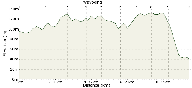
Ascent
60m (196ft)
Descent
114m (374ft)
Max. Elevation
140m (459ft)
Altitude Gain & Loss
174m (570ft)
Start
Sonning Common
End
Pangbourne
Distance
10.40km
(6.46mi)
(6.46mi)
Duration
~3:00h
Difficulty
Moderate
Ordnance Survey Maps
It's easy to find an enjoyable walk near Reading. The extensive bus network connects the town to many of the surrounding villages. The website www.roundreadingwalk.co.uk has 15 walks near the town, including this route through the beech woodlands of the beautiful Chiltern hills. And all these routes make a pleasurable alternative to a day at the Oracle shopping centre!
Walk Functions
Share
Nearby Walks
Circular walk around Sonning Common
A leisurely, circular walk (countryside) starting in Oxfordshire, England, about 8.20km (5.10 mi) long, duration: ~2:30h.A Thames walk from Pangbourne
A leisurely, linear walk (riverside) starting in West Berkshire, England, about 7.80km (4.85 mi) long, duration: ~2:15h.The Hughenden Estate
A moderate, linear walk (countryside) starting in Buckinghamshire, England, about 11.70km (7.27 mi) long, duration: ~3:45h.Walk Map
- $walk->POI array(0)
Waypoints
OS Grid SU707801
From the Post Office in Sonning Common, walk down Woodlands Rd into Old Copse. At the path junction in the woods, bear left towards New Copse.
OS Grid SU692804
Follow the bridleway just inside the woods to Gallowstree Common.
About 1.55 km (~0.96 miles) from 
OS Grid SU679798
Take the path through Withy Copse, signposted towards Cane End. At the Palm Tree restaurant, cross the Reading Road (A4074).
About 1.40 km (~0.87 miles) from 
OS Grid SU672791
Take the path through the woods to Newney Green, also known as Nuney Green. Follow the path heading southwest to the King Charles Head, formerly a pub (don't worry, there's one coming up).
About 1.03 km (~0.64 miles) from 
OS Grid SU663788
Cross the road and take the path signposted 'Path Hill'.
About 0.93 km (~0.58 miles) from 
OS Grid SU654783
Follow the path that runs along the northern edge of the lovely woods, typical of the Chilterns.
About 1.02 km (~0.63 miles) from 
OS Grid SU645784
The path heads out into farmland, heading westwards towards Whitchurch.
About 0.88 km (~0.55 miles) from 
OS Grid SU636788
Pass through the village, which has some interesting old buildings, including a Norman church.
About 1.00 km (~0.62 miles) from 
OS Grid SU633780
Follow the path from Whitchurch south to Pangbourne.
About 0.92 km (~0.57 miles) from 
 Pangbourne
OS Grid SU635767
It's a short walk along the road to Pangbourne, on the River Thames. Plenty of pubs to make up for the closed one earlier. There are trains back to Reading, or buses if you bought a day ticket. More great walks around Reading at roundreadingwalk.co.uk
About 1.26 km (~0.78 miles) from 
