Wallyford to Musselburgh
A leisurely walk (countryside) starting and finishing in East Lothian, Scotland, about 7.80km (4.85 mi) long with an estimated walking time of about 2:30h. It is suitable for families with children, but unsuitable for prams & pushchairs, wheelchairs.
Elevation Profile
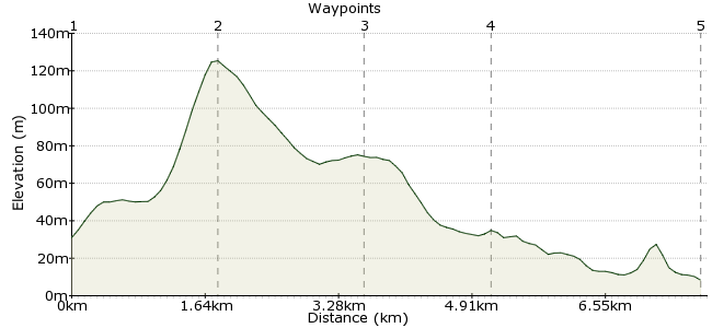
Ascent
97m (318ft)
Descent
119m (390ft)
Max. Elevation
130m (426ft)
Altitude Gain & Loss
216m (708ft)
Start
Wallyford
End
Musselburgh
Distance
7.80km
(4.85mi)
(4.85mi)
Duration
~2:30h
Difficulty
Leisurely
A fairly low-level walk up a raised beach, past some farmland, through a woodland, along a disused railway and on a riverside path. Lots of historical interest. About 8 miles.
Walk Functions
Share
Nearby Walks
Edinburgh's volcano
A leisurely, circular walk (city/town) starting in City of Edinburgh, Scotland, about 6.60km (4.10 mi) long, duration: ~2:30h.Pentlands Capital View Walk
A leisurely, circular walk (countryside) starting in Midlothian, Scotland, about 1.70km (1.06 mi) long, duration: ~0:45h.River North Esk Circular
A leisurely, circular walk (woodland) starting in Midlothian, Scotland, about 5.20km (3.23 mi) long, duration: ~1:30h.Walk Map
- $walk->POI array(0)
Waypoints
OS Grid NT368723
Start of the walk
OS Grid NT376708
Start at Wallyford Train Station and walk up to the town. Turn right then left into Inchview Road. Follow this road until it becomes a track. At the junction turn right and left at the fork. Follow this path to the mast, turn left and walk over the footbridge. Continue uphill to Fa'side Castle
About 1.75 km (~1.09 miles) from 
OS Grid NT363697
Continue along road downhill and turn left into track. At junction turn right and follow farm track to Hillhead Farm. Turn left, turn right along road until a gap in the wall. Enter forest and follow main path to car park. Follow track around Carberry Tower on your left until you reach main road.
About 1.77 km (~1.1 miles) from 
OS Grid NT348700
Turn right, follow road on pavement until house on left. Follow track and go up to disused railway. Turn right and follow into Whitecraig. Turn left and walk through Village to the Roundabout. Turn right and walk to the end with path ahead.
About 1.55 km (~0.96 miles) from 
 Musselburgh High Street
OS Grid NT342725
Continue on the tarmac path with River Esk on your left until you reach Musselburgh.
About 2.57 km (~1.6 miles) from 
