Seaton Meadows
A moderate walk (countryside) in Rutland, England, about 17.90km (11.12 mi) long with an estimated walking time of about 5:30h. It is suitable for families with children, but unsuitable for prams & pushchairs, wheelchairs.
Elevation Profile
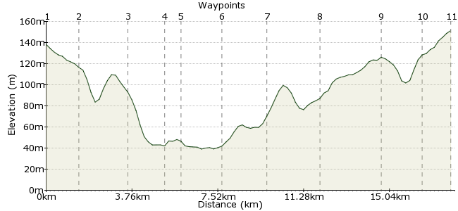
Ascent
117m (383ft)
Descent
104m (341ft)
Max. Elevation
160m (524ft)
Altitude Gain & Loss
221m (724ft)
Start & End
Uppingham
Distance
17.90km
(11.12mi)
(11.12mi)
Duration
~5:30h
Difficulty
Moderate
Ordnance Survey Maps
This route, across the countryside of Rutland and northern Northamptonshire, connects several villages in this tranquil region. The highlight is Seaton Meadows, a wet meadow with the magnificent Wellands Viaduct forming the backdrop. Keep your eyes peeled for the forked-tailed red kites, which circle high above the meadow. Good bus connections to and from Uppingham, plus some infrequent services to the villages along the way if you want a shorter route,
Walk Functions
Share
Nearby Walks
A countryside stroll in Rutland
A leisurely, circular walk (countryside) starting in Rutland, England, about 8.20km (5.10 mi) long, duration: ~2:30h.Stamford to Collyweston via the Welland
A moderate, circular walk (countryside) starting in Lincolnshire, England, about 14.70km (9.13 mi) long, duration: ~4:30h.Attenborough Nature Reserve and the Trent Valley Way
A moderate, linear walk (riverside) starting in Nottinghamshire, England, about 10.00km (6.21 mi) long, duration: ~2:45h.Walk Map
- $walk->POI array(0)
Waypoints
OS Grid SP870997
Take the bus to Uppingham and head to the eastern side of the town, to pick up the footpath to Bisbrooke.
OS Grid SP885996
Head through Bisbrooke and on towards Seaton.
About 1.51 km (~0.94 miles) from 
OS Grid SP901983
Cross the old dismantled railway and continue into Seaton. The Rutland Round, which also passes through the village, is a longer walk around this pleasant corner of England.
About 2.02 km (~1.26 miles) from 
OS Grid SP910971
The high point of the walk is the Welland Viaduct, a 1-km long Victorian structure that spans Seaton Meadows, one of the few unimproved flood meadows in the country. It's a nature hotspot, with many meadow flowers and plenty of birds, including the majestic red kite.
About 1.49 km (~0.93 miles) from 
OS Grid SP917973
Continue into Harringworth, and a mid-walk drink in the White Swan on Seaton Road.
About 0.71 km (~0.44 miles) from 
OS Grid SP929987
On the eastern side of the village, the Jurassic Way heads northeast along the river towards Barrowden, picking up the dismantled railway route once more.
About 1.79 km (~1.11 miles) from 
OS Grid SK942001
Continue into Barrowden. There are buses every two hours back to Uppingham during the day. Alternatievly head west along the road to Morcott.
About 1.88 km (~1.17 miles) from 
OS Grid SK920008
In Morcott you can leave the road and join the footpath through countryside - a much nicer alternative.
About 2.25 km (~1.4 miles) from 
OS Grid SK894004
Nearly finished at Glaston. To avoid walking along the main road, cross it and return to Bisbrooke.
About 2.68 km (~1.67 miles) from 
OS Grid SP876996
Pass through Bisbrooke and into Uppingham.
About 1.88 km (~1.17 miles) from 
 Uppingham again
OS Grid SP864998
Finished! The Crown Hotel on the High Street is the drinking hole of choice.
About 1.24 km (~0.77 miles) from 
