Telscombe village
A moderate walk (low hills and fells (below 600m)) in national park South Downs in East Sussex, England, about 13.70km (8.51 mi) long with an estimated walking time of about 4:15h. It is unsuitable for families with children, prams & pushchairs, wheelchairs.
Elevation Profile
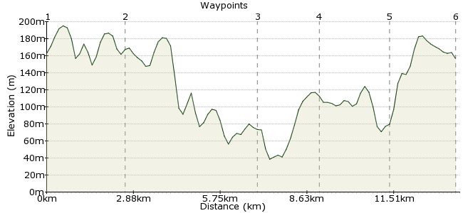
Ascent
124m (406ft)
Descent
130m (426ft)
Max. Elevation
200m (656ft)
Altitude Gain & Loss
254m (832ft)
Start & End
Woodingdean High Street
Distance
13.70km
(8.51mi)
(8.51mi)
Duration
~4:15h
Difficulty
Moderate
Ordnance Survey Map
This walk covers a quiet section of the South Downs, starting and finishing in the village of Woodingdean. The route starts by going through the beautiful Castle Hill Nature Reserve and then follows a stretch of the South Downs Way before heading to remote Telscombe. Despite being close to the busy south coast, this tiny hamlet feels a long way from anywhere. A perfect way to enjoy one of the most beautiful parts of southeast England.
Walk Functions
Share
Nearby Walks
Falmer to Lewes
A moderate, linear walk (low hills and fells (below 600m)) starting in Brighton and Hove, England, about 12.80km (7.95 mi) long, duration: ~4:00h.Castle Hill Nature Reserve - car-free thanks to cooking oil!
A leisurely, circular walk (low hills and fells (below 600m)) starting in East Sussex, England, about 5.50km (3.42 mi) long, duration: ~2:00h.Basin Stroll
A leisurely, linear walk (countryside) starting in East Sussex, England, about 6.60km (4.10 mi) long, duration: ~2:15h.Walk Map
- $walk->POI array(0)
Waypoints
OS Grid TQ356064
Start of the walk. Woodingdean is easy to reach by bus. The start is just a short walk uphill from the end of the line of shops - look for the car park on the brow of the hill.
OS Grid TQ378078
From the starting point, take the left hand path heading northeast. At the first footpath junction, take the right hand path which joins the South Downs Way. Follow the South Downs Way to the edge of the ridge, where you get views over Kingston village.
About 2.66 km (~1.65 miles) from 
OS Grid TQ414054
Follow the South Downs Way until you reach Mill Hill. From here you can follow the main path to Telscombe, or take the path heading though the valley.
About 4.29 km (~2.67 miles) from 
OS Grid TQ395044
Follow the path to the bridleway. Then head northwest along the bridleway.
About 2.06 km (~1.28 miles) from 
OS Grid TQ377058
Follow the bridleway until you reach a bridleway heading due north (379051). Follow this to Standean Bottom.
About 2.28 km (~1.42 miles) from 
 Woodingdean
OS Grid TQ355064
Follow the bridleway around the valley back to the start and take your bus home!
About 2.27 km (~1.41 miles) from 

1 comment... join the discussion!
GaryShipp
Catch the Big Lemon bus - you can almost smell the chips!