Conway Mountain
A leisurely walk (low hills and fells (below 600m)) in Clwyd, Wales, about 7.20km (4.47 mi) long with an estimated walking time of about 2:30h. It is suitable for families with children, but unsuitable for prams & pushchairs, wheelchairs.
Elevation Profile
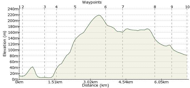
Ascent
188m (616ft)
Descent
118m (387ft)
Max. Elevation
220m (721ft)
Altitude Gain & Loss
306m (1003ft)
Start & End
Conwy
Distance
7.20km
(4.47mi)
(4.47mi)
Duration
~2:30h
Difficulty
Leisurely
Ordnance Survey Map
 1Created by driver 16 on 17 Apr 2011
A circular, half day walk, grndstand views of Conway Bay,Great Orme (see visitorreview.com/carfreewalks/llandudnogreatorme), begins in Conway, stronghold of Edward I, where his castle dominates the estuary (see visitorreview.com/carfreewalks/ConwayTown).  Â
Walk Functions
Share
Nearby Walks
Conway
A leisurely, circular walk (city/town) starting in Clwyd, Wales, about 3.30km (2.05 mi) long, duration: ~1:00h.Llandudno, Llanrhos and Deganwy-Llandudno
A moderate, circular walk (coast) starting in Clwyd, Wales, about 12.40km (7.71 mi) long, duration: ~4:15h.Llandudno-Conway RSPB reserve
A leisurely, linear walk (riverside) starting in Clwyd, Wales, about 7.20km (4.47 mi) long, duration: ~2:00h.Walk Map
- $walk->POI array(0)
Waypoints
OS Grid SH781776
Jarrold short walks book 14 Snowdonia, walk no. 20 Conway mountain, head down to Quay to start of walk.
OS Grid SH781778
Pass Liverpool Arms on left, pass "The Smallest House in Great Britain" on left, pass through arch at end of quay, turn left uphill for about 50yds, look right to see path along estuary and go down to join path and follow to reach school, just after footbridge over stream to school sport ground waypoint 3.
About 0.20 km (~0.12 miles) from 
OS Grid SH775784
Turn left, keeping school on your left, to reach main road, you will see footbridge over railway, cross road and cross this footbridge to waypoint 4.
About 0.82 km (~0.51 miles) from 
OS Grid SH774779
Follow track, keeping wall on your left, to a surfaced lane and a road junction, turn right, pass houses, where the track levels, look up to the right to see a ladder stile, climb over and head for waypoint 5.
About 0.44 km (~0.27 miles) from 
OS Grid SH767779
After a hard climb to reach a waymarked pole, branch right to reach wide grassy path, turn left onto this path, ahead along crest of mountain, keep top of mountain on your right, passing signboard for old hillfort, I couldn't find fort, see if you can !!!!! head for waypoint 6.
About 0.72 km (~0.45 miles) from 
OS Grid SH754775
Pass Pen-pyra farm, down to ford with stepping stones, turn left along farm access track which brings you to the head of Sychnant pass and waypoint 7.
About 1.30 km (~0.81 miles) from 
OS Grid SH749771
Cross road, see the gate in the wall, go through, follow to reach overhead cables, take left fork, descend to reach ladder stile at wall corner, climb over, keep lake on your left to reach track, turn right to reach out buildings, bear left descend steeply to narrow road, turn right, keep Ty Coch Farm on left, just before next house Y Bwthyn, go through kissing gate, in about 50yds., go through 2nd. kissing gate and head for waypoint 8.
About 0.68 km (~0.42 miles) from 
OS Grid SH759762
Keep house on your left, cross field to drive of house, see wooden gate to go through, obvious walkway through 1st. field, 2nd. field, when in third field, see red roof of white house, bear right to reach gate into lane, and waypoint 9.
About 1.32 km (~0.82 miles) from 
OS Grid SH763766
Take no notice of footpath sign (it has been turned round), turn right onto lane to pass Oakwood park, reach T junction, turn right, and in 20yds. left onto signposted path across rough ground through fields, the ponies are friendly, reach kissing gate waypoint 10.
About 0.61 km (~0.38 miles) from 
 Sychnant pass road
OS Grid SH764773
After passing through kissing gate, turn left, onto main tarmac road, keep fields on your left, houses on your right, downhill, passing Youth Hostel, ending up back in Conway.
About 0.69 km (~0.43 miles) from 
