Cosmeston to Sully Circuit
A leisurely walk (coast) in Vale of Glamorgan (Bro Morgannwg), Wales, about 7.70km (4.78 mi) long with an estimated walking time of about 2:15h. It is suitable for families with children, but unsuitable for prams & pushchairs, wheelchairs.
Elevation Profile
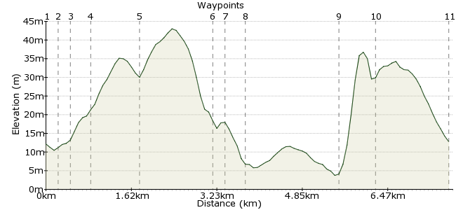
Ascent
45m (147ft)
Descent
44m (144ft)
Max. Elevation
50m (164ft)
Altitude Gain & Loss
89m (291ft)
Start & End
Cosmeston Lakes
Distance
7.70km
(4.78mi)
(4.78mi)
Duration
~2:15h
Difficulty
Leisurely
Ordnance Survey Map
A level, easy walk, but farm gateways will be very muddy after rain, boots definitely required. Cardiff Bus route 94 will take you to Cosmeston Lakes Country Park.
This walk comes from the Cardiff Ramblers: www.cardifframblers.org.uk
Walk Functions
Share
Nearby Walks
Oriel Canfas
A leisurely, circular walk (city/town) starting in Cardiff, Wales, about 4.80km (2.98 mi) long, duration: ~1:15h.Cardiff City
A leisurely, circular walk (city/town) starting in Cardiff, Wales, about 6.90km (4.29 mi) long, duration: ~2:00h.Taff and Ely Circular
A leisurely, linear walk (riverside) starting in Cardiff, Wales, about 6.70km (4.16 mi) long, duration: ~1:45h.Walk Map
- $walk->POI array(0)
Waypoints
OS Grid ST179692
Go from Cosmeston car park to nearest lakeside. Turn left and take boardwalk passing behind cafe and, after 1100 metres, where boardwalk forks, go left. Shortly after end of boardwalk path meets wide cross track there are views over the second lake from here.
OS Grid ST176690
Go left, following track for 100 metres, and then go over stile on your right with footpath sign.
About 0.30 km (~0.19 miles) from 
OS Grid ST176688
Walk half -left uphill, keeping just to the right of some old walls. Then go through gateway ahead at field corner. Keep to the left edge of field as it curves to the right and then to the left. There are views on the right over Cosmeston lakes. Look out for partly hidden stile on the left about 100 metres before fence at end of field. Go over stile to left then immediately turn and go over second stile/old gate which brings you into corner of next field.
About 0.18 km (~0.11 miles) from 
OS Grid ST173688
Now head diagonally left uphill towards some small hillocks on skyline. Pass to the right of these. Two gates are now ahead. Go through the one on the right. Then keeping to left field edge, walk to the right of the barns and leave farm at stile in corner of field, near farmhouse. Walk down farm entrance drive to road
About 0.32 km (~0.2 miles) from 
OS Grid ST164688
Cross to road opposite, signposted "Sully -Barry". Walk this road for about 500 metres to Sully. There is no footpath, so take care, especially on bends, Continue on this road, Cog Road, through he village for about 750 metres, ignoring side turns. Look out for Sully Inn on the left and 50 metres beyond keep to left hand pavement as it curves left in front of church.
About 0.89 km (~0.55 miles) from 
OS Grid ST151683
Walk past the bus shelter and, 50 metres beyond it, cross road and take signed footpath at kissing gate.
About 1.38 km (~0.86 miles) from 
OS Grid ST151682
Take this path to sea front.
About 0.17 km (~0.11 miles) from 
OS Grid ST152679
Go left over shingle beach in front of houses, soon joining a coastal path; near old boat slipway. The attractive view ahead now shows three islands; from the left, Flat Holm, Sully Island and Steep Holm. Keep to the coast path for about I km as, on the landward side, you pass houses, sportsfield, boatyard Hand more houses. A large sportsfield is ahead. Keep to the perimeter path of this, above the beach. Some 50 metres before fenced caravan park look out for large wooden post and remains of old metal stile/gate on seaward (right side). Go right and down steps to the beach. Keeping to the left walk for 200 metres over fairly flat, but broken and in parts slippery, rock and then go up stone steps to cafes and Swanbridge car park/promenade. Please note that if tide is high and it is preferable to avoid this beach section, then keep to sports field path, pass to the left of caravan park and join road where fence ends. Go right and then down road to Swanbridge.
About 0.31 km (~0.19 miles) from 
OS Grid ST168674
It is possible to walk over to Sully Island from here at low tide. But check tide times carefully, the island is usually only accessible for about 2 hours either side of low water and the incoming tide is very dangerous. Walk east across car park keeping to coast until you reach a small gateway which takes you onto coastal road.
About 1.71 km (~1.06 miles) from 
OS Grid ST174677
Go up, keeping to this road for about 1.5 kms to the B4267 Penarth-Sully road. Cross this road to track opposite, there are Cosmeston Park notices on gate. Walk on and the recreated mediaeval village soon appears on the right. Take the metalled lane on right, signed to the village, and then, unless you want to visit the village, go left at village entrance, over bridge and boardwalk to regain car park.
If you are still raring to go, the walk may be easily extended by use of the paths around both lakes. Refreshments are usually available at cafes at Cosmeston and Swanbridge and inns at Sully and Swanbridge.
About 0.63 km (~0.39 miles) from 
 Comeston Park
OS Grid ST177690
Return to Comeston Park for the bus back home.
About 1.36 km (~0.85 miles) from 
