The eastern Mamores
A moderate walk (mountain (above 600m)) in Highlands, Scotland, about 13.40km (8.33 mi) long with an estimated walking time of about 7:00h. It is unsuitable for families with children, prams & pushchairs, wheelchairs.
Elevation Profile
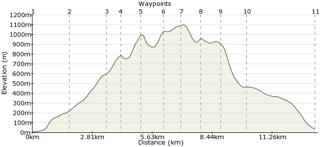
Ascent
1074m (3523ft)
Descent
1050m (3444ft)
Max. Elevation
1110m (3641ft)
Altitude Gain & Loss
2124m (6967ft)
Start & End
Kinlochleven
Distance
13.40km
(8.33mi)
(8.33mi)
Duration
~7:00h
Difficulty
Moderate
Ordnance Survey Map
This extended ridge is one of Scotland's highlights. The most famous peaks are those of the Ring of Steall (best accessed from the other side) but the eastern tops of the range - Na Gruagaichean, Binnein Mor and Sgor Eilde Beag are easily their equal. Base yourself in Kinlochleven, which is a stop on the bus routes heading north to Fort William.
Walk Functions
Share
Nearby Walks
A low-level walk along the lochs
A moderate, linear walk (low hills and fells (below 600m)) starting in Highlands, Scotland, about 21.00km (13.05 mi) long, duration: ~7:30h.Glencoe to the Clachaig Inn
A moderate, circular walk (riverside) starting in Highlands, Scotland, about 10.10km (6.28 mi) long, duration: ~3:00h.Sgor na h-Ulaidh in Glencoe
A moderate, circular walk (mountain (above 600m)) starting in Highland, Scotland, about 17.20km (10.69 mi) long, duration: ~7:45h.Walk Map
- $walk->POI array(0)
Waypoints
OS Grid NN185618
A regular stop-off on the West Highland Way, Kinlochleven is where to base yourself for a Mamores trip.
OS Grid NN192635
Take the path heading north out of town, which follows Allt Coire na Ba.
About 1.78 km (~1.11 miles) from 
OS Grid NN194652
The path switches back and forth as it climbs beneath the shadow of Am Bodach.
About 1.73 km (~1.07 miles) from 
OS Grid NN192657
Join the main ridge path between Stob Coire a' Chairn and Na Guragaichean. If you're feeling fresh, take in the summit of Stob Coire a' Chairn before heading east along the ridge.
About 0.55 km (~0.34 miles) from 
OS Grid NN201654
It's a scrambly ascent up to this one.
About 0.98 km (~0.61 miles) from 
OS Grid NN211656
Follow the ridge east as it drops down and then rises to a nameless peak. Store your backpack by the cairn for an easier trot over to Binnein Mor.
About 1.02 km (~0.63 miles) from 
OS Grid NN211664
This is one of those fine-looking peaks that define Scotland. Best seen from the Water of Nevis - you can drop down there for a wild camp if you want to spend longer in the hills.
About 0.77 km (~0.48 miles) from 
OS Grid NN213655
Retrace your steps and rejoin the ridge heading east.
About 0.88 km (~0.55 miles) from 
OS Grid NN220651
This is the final top of the day - admire the views back along the length of the Mamores before you drop off via the path on the eastern shoulder.
About 0.87 km (~0.54 miles) from 
OS Grid NN216641
The return path curves across the southern flanks of the Mamores, overlooking Loch Eilde Mor.
About 1.11 km (~0.69 miles) from 
 Kinlochleven again
OS Grid NN188623
Return to the town for the bus home.
About 3.25 km (~2.02 miles) from 
