Dinas Head on the Pembrokeshire Coast
A moderate walk (coast) in national park Pembrokeshire Coast starting and finishing in Pembrokeshire (Sir Benfro), Wales, about 12.60km (7.83 mi) long with an estimated walking time of about 4:00h. It is suitable for families with children, but unsuitable for prams & pushchairs, wheelchairs.
Elevation Profile
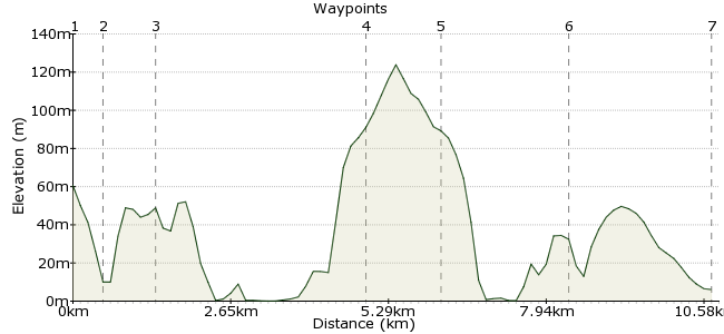
Ascent
114m (374ft)
Descent
169m (554ft)
Max. Elevation
130m (426ft)
Altitude Gain & Loss
283m (928ft)
Start
Fishguard
End
Newport, Dyfed, Wales
Distance
12.60km
(7.83mi)
(7.83mi)
Duration
~4:00h
Difficulty
Moderate
Ordnance Survey Map
The spectacular scenery of the Pembrokeshire Coast National Park – cliff-tops coated with wild flowers, gorse and purple heather, towering above the rocky beaches below – creates the perfect setting for a host of great walks. And good train and bus connections make it easy to get around the region car-free. The landscape is dotted with small towns and villages, and the best way to explore is to simply pick a couple of villages a good distance apart (and with bus connections) and wander from A to B.
This route starts at Fishguard, which is easily reached by bus and has train connections too. It then passes DInas Head and a particularly spectacular section of coastline, before finishing at Trefdraeth.
Walk Functions
Share
Nearby Walks
Carningli Common and Cwm Gwaun
A moderate, circular walk (riverside) starting in Pembrokeshire (Sir Benfro), Wales, about 18.40km (11.43 mi) long, duration: ~6:45h.Moylgrove to St. Dogmaels.
A moderate, walk (coast) starting in Pembrokeshire, Wales, about 11.60km (7.21 mi) long, duration: ~3:45h.Newgale to Solva
A leisurely, linear walk (coast) starting in Pembrokeshire (Sir Benfro), Wales, about 6.00km (3.73 mi) long, duration: ~1:45h.Walk Map
- $walk->POI array(0)
Waypoints
OS Grid SM956370
Take the train or bus to Fishguard (note that Fishguard Harbour station is about a mile north of the town) and fight your way through the crowds of tourists that flock to this popular town. The busy harbour is worth a visit before you set out for the day.
OS Grid SM963372
Heading west through the town, you cross the Afon Gwuan via the A487 road bridge. Over the bridge, the Pembrokeshire Coast Path heads north along the cliffs.
About 0.65 km (~0.4 miles) from 
OS Grid SM971377
Once you have left the town behind, it’s glorious coastline all the way. Wildlife is plentiful around Fishguard; stonechats, fulmars and cormorants are regularly seen from the Coast Path, and you may spot grey seals, dolphins or porpoises in Fishguard Bay below.
About 0.93 km (~0.58 miles) from 
OS Grid SN005398
Break up your walk with a drink at the Old Sailors pub at Pwllgwaelod, on the western edge of the headland. Once a watering hole for smugglers, today it’s popular with tourists and families. You can still get a rum, though.
About 4.03 km (~2.5 miles) from 
OS Grid SN007412
The path continues north-eastwards to Dinas Head, a dramatic headland managed by the National Trust. The cliffs are 465m high, with incredible views of the surrounding area. The headland itself is awash with wildflowers.
About 1.34 km (~0.83 miles) from 
OS Grid SN025395
The path continues east past Newport Bay, wiggling in and out of this sinuous coastline.
About 2.41 km (~1.5 miles) from 
 Trefdraeth / Newport
OS Grid SN053395
Finish at the village of Trefdraeth; if the sun’s still shining, enjoy an ice cream at Newport Sands. The 412 bus will take you back to Fishguard (check times at Fishguard before you leave). It goes roughly every hour (less frequently on Sundays and Bank Holidays).
About 2.85 km (~1.77 miles) from 

1 comment... join the discussion!
icross
Hi Is there a problem with a the gpx file. I was unable to open with easygps? Regards Ian