Goat Fell
A moderate walk (mountain (above 600m)) in Ayrshire, Scotland, about 14.00km (8.70 mi) long with an estimated walking time of about 6:30h. It is unsuitable for families with children, prams & pushchairs, wheelchairs.
Elevation Profile
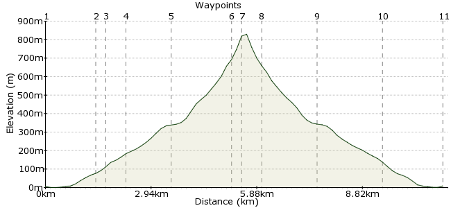
Ascent
846m (2775ft)
Descent
843m (2765ft)
Max. Elevation
830m (2723ft)
Altitude Gain & Loss
1689m (5540ft)
Start & End
Brodick
Distance
14.00km
(8.7mi)
(8.7mi)
Duration
~6:30h
Difficulty
Moderate
Ordnance Survey Map

Walk Functions
Share
Nearby Walks
Goatfell and Coire na Ciche on the Isle of Arran
A moderate, linear walk (mountain (above 600m)) starting in Ayrshire, Scotland, about 10.00km (6.21 mi) long, duration: ~5:15h.Cir Mhor from Mid Sannox
A moderate, circular walk (mountain (above 600m)) starting in Ayrshire, Scotland, about 12.10km (7.52 mi) long, duration: ~5:45h.The Cock of Arran
A moderate, circular walk (coast) starting in Ayrshire, Scotland, about 10.10km (6.28 mi) long, duration: ~3:00h.Walk Map
- $walk->POI array(0)
Waypoints
OS Grid NS021358
The walk starts in Brodick, largest town on Arran.
OS Grid NS014375
Walk to Cladach in a northerly direction via the beach. If you're in a rush, there's a bus from the ferry terminal.
About 1.77 km (~1.1 miles) from 
OS Grid NS010376
Cross the main road and head towards the pink Wineport Bar building. Take the path to the right of the building and head past a camping stores shop and an entrance to Brodick Castle on the right. The path to Goatfell is clearly marked from this point.
About 0.36 km (~0.22 miles) from 
OS Grid NS007382
Follow the path through woodland until you reach a stony track heading north.
About 0.68 km (~0.42 miles) from 
OS Grid NR999395
Follow the well defined path north through predominantly forestry woodland. This opens up to sparse native woodland. Follow the path to the footbridge.
About 1.54 km (~0.96 miles) from 
OS Grid NR996415
From the footbridge proceed through a large wooden gate. Continue north on the well defined path which becomes steeper and more rocky.
About 1.95 km (~1.21 miles) from 
OS Grid NR991415
From the junction of the paths continue uphill in an easterly direction. The path is less well defined than earlier, but still clear even in poor visibility. The summit is marked with a trig point and a map showing the peaks that can be picked out on a good day. On a clear day you can see past the Mull of Kintyre to Ireland.
About 0.47 km (~0.29 miles) from 
OS Grid NR997415
Retrace your steps down from the summit
About 0.53 km (~0.33 miles) from 
OS Grid NS000395
Taking the right fork at the junction of the paths head back towards the footbridge.
About 1.96 km (~1.22 miles) from 
OS Grid NS011376
Head back through forestry land to Wineport Bar Restaurant
About 2.22 km (~1.38 miles) from 
 Ferryport, Brodick
OS Grid NS020358
Arrive back at the ferry port, either walking from Cladach via the beach, or on the bus.
About 2.05 km (~1.27 miles) from 

2 comments... join the discussion!
Timwoods
Glad to hear it! It's years since I've been, working its way up a very long 'to do again' list.
Gary Yemm
Went on this walk last Sunday, enjoyed it so much going back tomorrow to do it again. hope the weather is clearer at the top this time. kind Regards Gary.