Achmelvich Beach
A moderate walk (coast) in Highlands, Scotland, about 12.90km (8.02 mi) long with an estimated walking time of about 4:00h. It is suitable for families with children, but unsuitable for prams & pushchairs, wheelchairs.
Elevation Profile
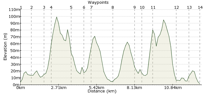
Ascent
166m (544ft)
Descent
169m (554ft)
Max. Elevation
100m (328ft)
Altitude Gain & Loss
335m (1098ft)
Start & End
Lochinver
Distance
12.90km
(8.02mi)
(8.02mi)
Duration
~4:00h
Difficulty
Moderate
Ordnance Survey Map
Achmelvich is one of the west coast's most beautiful sandy beaches. It can be visited in the summer months (April-September) as a day trip from Inverness, using the Durness cycle bus, Â which calls at Lochinver around midday and picks up again some five hours later. Â This allows long enough to walk along a moorland path to the beach and back, with a couple of hours to relax on the white sand. Or investigate the campsite or hostel for a longer stay, both are right by the beach.... Â Â
Walk Functions
Share
Nearby Walks
Lochinver to Elphin
A strenuous, linear walk (low hills and fells (below 600m)) starting in Highlands, Scotland, about 21.00km (13.05 mi) long, duration: ~6:45h.Little Assynt to Lochinver
A moderate, linear walk (low hills and fells (below 600m)) starting in Highlands, Scotland, about 11.90km (7.39 mi) long, duration: ~4:00h.Faraid Head, Sutherland
A moderate, circular walk (coast) starting in Highlands, Scotland, about 10.30km (6.40 mi) long, duration: ~3:15h.Walk Map
- $walk->POI array(0)
Waypoints
OS Grid NC093223
The bus stops in the centre of the village. Turn left and retrace the route back to where a minor road turns off to the left, just before the main road crosses a stream by a bridge and begins to climb uphill.
OS Grid NC096230
Follow the road past the church, through the built -up area, to the point where the road divides. Take the right hand turning here. The road continues uphill, and at a bend in the road, turn left to gain a footpath which passes close to a house, leading to a gate opening onto open moorland.
About 0.74 km (~0.46 miles) from 
OS Grid NC086229
Turn right where the road forks, and continue uphill. At a bend in the road, turn left onto a footpath which passes close to a house before reaching a gate onto open moorland.
About 0.99 km (~0.62 miles) from 
OS Grid NC083232
A clear path now meanders between low rocky humps and occasional lochans. It is worth diverting off the path onto one of these humps for a view down to the sea. The inland view is dominated by a line up of oddly shaped mountains; these are the hills of Assynt with distinctive names and profiles - Suilven, Canisp, Quinag....
About 0.37 km (~0.23 miles) from 
OS Grid NC070236
Eventually the narrow path emerges onto a more substantial track, passing some crofting buildings, then skirting Loch Dubh.
About 1.42 km (~0.88 miles) from 
OS Grid NC072244
The road drops down to cross the stream running into Loch Roe, via a bridge. It then bears uphill, passing through woodland, to join the minor road leading to Achmelvich.
About 0.85 km (~0.53 miles) from 
OS Grid NC070248
Turn left onto the twisty minor road that leads to Achmelvich - being aware that this narrow road is used by caravans and the occasional local bus.
About 0.43 km (~0.27 miles) from 
OS Grid NC055247
At last the destination comes into sight - Achmelvich Beach itself. A white, sandy beach between grassy headlands, almost tropical-looking (until you dip your hot feet into the clear seawater, guaranteed to cool them down fast!). To extend your time here, there is a campsite and a small SYHA hostel right on the beach (open during the summer). Otherwise, the return route to Lochinver is the same as the outward walk. The dome of Suilven is particularly striking from this angle.
About 1.50 km (~0.93 miles) from 
OS Grid NC070247
Turn right and get away from what little traffic there is.
About 1.52 km (~0.94 miles) from 
OS Grid NC072243
Cross the bridge and continue up to the croft buildings, where the footpath branches off.
About 0.48 km (~0.3 miles) from 
OS Grid NC071235
Follow the winding footpath across the moorland to the gate which takes you back onto a tarred road.
About 0.80 km (~0.5 miles) from 
OS Grid NC086228
Turn left and walk back to the junction with the A837.
About 1.69 km (~1.05 miles) from 
OS Grid NC095229
Turn right here to return to the centre of Lochinver, which has shops and refreshment possibilities before catching the return bus to Inverness.
About 0.88 km (~0.55 miles) from 
 Lochinver centre again
OS Grid NC093222
Picnic benches by the bus turning area afford views out along the sea loch while you wait. There is now a community-run hostel near the harbour, if you want to extend your stay in Lochinver to take in, for example, the Falls of Kirkaig (or have simply missed the bus, lingering too long on that idyllic beach!)
About 0.73 km (~0.45 miles) from 
