A walk through Epping Forest
A leisurely walk (woodland) starting and finishing in Essex, England, about 8.70km (5.41 mi) long with an estimated walking time of about 2:45h. It is suitable for families with children, but unsuitable for prams & pushchairs, wheelchairs.
Elevation Profile
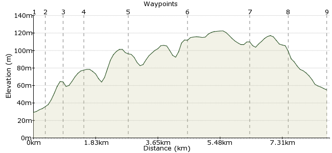
Ascent
83m (272ft)
Descent
58m (190ft)
Max. Elevation
130m (426ft)
Altitude Gain & Loss
141m (462ft)
Start
Loughton
End
Theydon Bois, Epping, Essex, England
Distance
8.70km
(5.41mi)
(5.41mi)
Duration
~2:45h
Difficulty
Leisurely
Ordnance Survey Map
Epping Forest is one of those patches of green that make London such a great city for people who love the outdoors. Tucked away in the northeast corner of the city, it is easily reached via the underground system so accessible for the whole city.
There's plenty to see and do in the forest, enough for a whole day's entertainment. This route is my suggestion for exploring, but other websites have lots more info on what to see and do. Try the following:
http://bit.ly/uhfl1b
http://bit.ly/6ZlEq5
Walk Functions
Share
Nearby Walks
Lea Valley New River walk
A leisurely, circular walk (riverside) starting in City of London, England, about 4.90km (3.04 mi) long, duration: ~1:15h.The Parkland Walk
A leisurely, linear walk (city/town) starting in City of London, England, about 6.00km (3.73 mi) long, duration: ~1:45h.The Pymmes Brook Trail
A moderate, linear walk (city/town) starting in City of London, England, about 16.40km (10.19 mi) long, duration: ~4:30h.Walk Map
- $walk->POI array(0)
Waypoints
OS Grid TQ422956
Loughton Tube Station is on the Central Line, or you can get a bus there.
OS Grid TQ420959
Little bit of navigation to get to the forest. There are signs, but an A-Z might be useful. Head along Old Station Road, then cross the main road.
About 0.36 km (~0.22 miles) from 
OS Grid TQ416961
Follow the Three Forests Way along Gillard's Grove to Epping Forest.
About 0.46 km (~0.29 miles) from 
OS Grid TQ414966
The criss-cross network of paths means you can choose your own route within the forest. The main path runs through the main axis of the wood and is a good option fot those seeking a longish walk.
About 0.52 km (~0.32 miles) from 
OS Grid TQ420977
Continue along the main path. Despite being within the city boundary, it's a wonderfully peaceful place.
About 1.24 km (~0.77 miles) from 
OS Grid TQ433990
Continue to Jack's Hill. The northern section tends to be a bit quieter.
About 1.80 km (~1.12 miles) from 
OS Grid TL444003
The most northerly section is known as Epping Thicks.
About 1.73 km (~1.07 miles) from 
OS Grid TQ442993
You can walk right to the end and leave at Epping; Theydon Bois is another option and has the benefit of a good pub on the way to the station. Try the Queen Victoria on Coppice Row.
About 1.03 km (~0.64 miles) from 
 Theydon Bois Tube Station
OS Grid TQ453991
Continue along Coppice Row to reach the tube station.
About 1.18 km (~0.73 miles) from 
