The Tarrens
A moderate walk (low hills and fells (below 600m)) in national park Snowdonia starting and finishing in Gwynedd, Wales, about 13.50km (8.39 mi) long with an estimated walking time of about 5:30h. It is unsuitable for families with children, prams & pushchairs, wheelchairs.
Elevation Profile
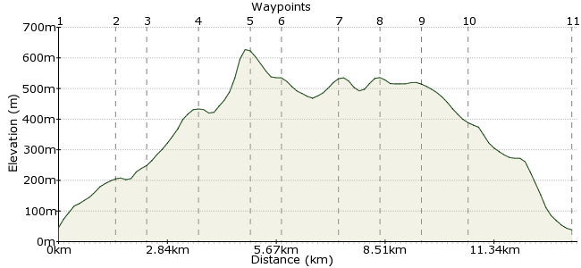
Ascent
573m (1879ft)
Descent
580m (1902ft)
Max. Elevation
630m (2066ft)
Altitude Gain & Loss
1153m (3781ft)
Start
Abergynolwyn
End
Bryncrug, Tywyn, Gwynedd, Wales
Distance
13.50km
(8.39mi)
(8.39mi)
Duration
~5:30h
Difficulty
Moderate
Ordnance Survey Map
The Tarrens are a range of hills at the southern end of Snowdonia. A far gentler proposition than the giants in the north of the National Park, they still offer some enjoyable walking and good views.
The experience is enhanced by the option of travelling to the start on the Talyllyn Railway: www.talyllyn.co.uk. This restored steam train weaves through the valley from Tywyn for the ultimate car-free start to the walk. if that is a bit pricey, you can also get a bus to the start point.
Walk Functions
Share
Nearby Walks
Cadair Idris the long way
A moderate, linear walk (mountain (above 600m)) starting in Gwynedd, Wales, about 15.50km (9.63 mi) long, duration: ~6:45h.Mawddach Way
A hard, circular walk (low hills and fells (below 600m)) starting in Gwynedd, Wales, about 39.30km (24.42 mi) long, duration: ~14:30h.Panorama Walk
A leisurely, circular walk (low hills and fells (below 600m)) starting in Gwynedd, Wales, about 7.30km (4.54 mi) long, duration: ~3:00h.Walk Map
- $walk->POI array(0)
Waypoints
OS Grid SH678069
Take the bus or steam train to Abergynolwen.
OS Grid SH689058
Follow the road from Nant Gwernol (where the station is if you come by train) along the stream and then continue into the forest.
About 1.57 km (~0.98 miles) from 
OS Grid SH694052
Take the footpath through the forest for 1km.
About 0.79 km (~0.49 miles) from 
OS Grid SH696040
Once you leave the forest, turn right and follow the path that runs along the forest boundary, heading uphill.
About 1.21 km (~0.75 miles) from 
OS Grid SH682039
The first peak you reach is Tarrenhendre.
About 1.37 km (~0.85 miles) from 
OS Grid SH682032
The path heads along the ridgeline of the Tarrens.
About 0.76 km (~0.47 miles) from 
 Mynydd Esgairweddan
OS Grid SH669025
The ridge path drops down at Mynydd Esgairweddan before climbing gently again.
About 1.49 km (~0.93 miles) from 
OS Grid SH654014
... and on to Trum Gelli, the last summit of the day.
About 0.92 km (~0.57 miles) from 
OS Grid SH642014
Drop off the western shoulder to meet the track.
About 1.17 km (~0.73 miles) from 
 Rhyd-yr-onen
OS Grid SH616021
Pick up the road and finish in Rhyd-yr-onen, where you can rejoin the steam train home. If you want to keep walking, follow the path along the valley floor to Tywyn.
About 2.73 km (~1.7 miles) from 
