Bollington and Rainow
A leisurely walk (countryside) in national park Peak District in Cheshire, England, about 5.20km (3.23 mi) long with an estimated walking time of about 1:30h. It is suitable for families with children, but unsuitable for prams & pushchairs, wheelchairs.
Elevation Profile
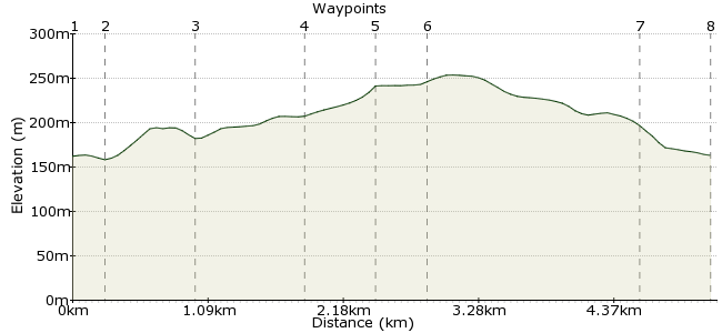
Ascent
89m (291ft)
Descent
88m (288ft)
Max. Elevation
260m (853ft)
Altitude Gain & Loss
177m (579ft)
Start & End
Bollington (Turners Arms bus stop)
Distance
5.20km
(3.23mi)
(3.23mi)
Duration
~1:30h
Difficulty
Leisurely
Ordnance Survey Map
A short walk in a lovely part of Cheshire, with a moderate climb. Nothing too strenuous or muddy, but mostly off-road.
Walk Functions
Share
Nearby Walks
The Gritstone Trail
A hard, linear walk (countryside) starting in Cheshire, England, about 53.60km (33.31 mi) long, duration: ~18:15h.Disley to Lyme Park circular walk
A leisurely, circular walk (low hills and fells (below 600m)) starting in Cheshire, England, about 8.70km (5.41 mi) long, duration: ~3:00h.Gritstone Trail around Bollington and Rainow
A strenuous, circular walk (low hills and fells (below 600m)) starting in Derbyshire, England, about 21.20km (13.17 mi) long, duration: ~7:30h.Walk Map
- $walk->POI array(0)
Waypoints
OS Grid SJ939779
Frequent buses from Macclesfield, and less frequent from Stockport.
OS Grid SJ939776
Walk down Church Street to the junction with Lord street
About 0.26 km (~0.16 miles) from 
OS Grid SJ942771
Walk up Ingersley Vale, past the mill pond and the derelict factory (note the water wheel housing from 1809) to the waterfall at Waulk Mill.
About 0.64 km (~0.4 miles) from 
OS Grid SJ946763
Follow the obvious paths in a southerly direction to arrive at Rainow village
About 0.84 km (~0.52 miles) from 
OS Grid SJ952761
Follow the road through the village to arrive at the Robin Hood pub
About 0.56 km (~0.35 miles) from 
OS Grid SJ953765
Follow the lane behind the pub to a junction. Take the cobbled bridleway to the left (Oakenbank Lane). The views from the highest point across to Manchester are breathtaking.
About 0.40 km (~0.25 miles) from 
OS Grid SJ944779
Follow Oakenbank Lane until you come to a small road junction. Turn left down Smithy Brow and Ingersley Road to Bollington.
About 1.62 km (~1.01 miles) from 
 Bollington
OS Grid SJ939779
Back in Bollington. Plenty of pubs, restaurants and takeaways.
About 0.51 km (~0.32 miles) from 
