Cosgate Hill to Countisbury
A moderate walk (coast) in national park Exmoor in Devon, England, about 12.40km (7.71 mi) long with an estimated walking time of about 4:30h. It is unsuitable for families with children, prams & pushchairs, wheelchairs.
Elevation Profile
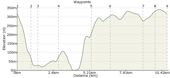
Ascent
377m (1236ft)
Descent
380m (1246ft)
Max. Elevation
350m (1148ft)
Altitude Gain & Loss
757m (2482ft)
Start & End
County Gate
Distance
12.40km
(7.71mi)
(7.71mi)
Duration
~4:30h
Difficulty
Moderate
Ordnance Survey Map
The first half of the walk is more challenging, hitting up natural highlights along the coast before cutting inland for lunch. Â The second half cuts throough Countisbury Common farm land before detouring to the Old Roman Fort at the end.
Walk Functions
Share
Nearby Walks
The moors of Exmoor
A strenuous, circular walk (moorland) starting in Devon, England, about 20.00km (12.43 mi) long, duration: ~7:15h.Exmoor's extraordinary coastline Part II
A moderate, linear walk (coast) starting in Devon, England, about 18.10km (11.25 mi) long, duration: ~7:15h.Lynton & Lynmouth
A leisurely, circular walk (coast) starting in Devon, England, about 5.70km (3.54 mi) long, duration: ~2:15h.Walk Map
- $walk->POI array(0)
Waypoints
OS Grid SS794486
Starting Point, County Gate Visitor's Centre
OS Grid SS799496
Point #1 along the coast
About 1.13 km (~0.7 miles) from 
OS Grid SS794498
Apparently a natural arch along the coast
About 0.54 km (~0.34 miles) from 
OS Grid SS779498
Meet up with the South West Coast Path after Giant's Rib. This looks like the first point past that.
About 1.53 km (~0.95 miles) from 
OS Grid SS754510
Minor detour from the Southwest Coast Path
About 2.76 km (~1.71 miles) from 
OS Grid SS747497
According to the map, there's a pub here where we can have lunch. I asked Google, and I think this is probably the place. http://www.exmoorsandpiper.com/pub.htm
About 1.47 km (~0.91 miles) from 
OS Grid SS773493
Apparently the farms along the way here have granted "at your risk" right-of-way passage. It should be a bit easier than the pre-lunch half of the hike.
About 2.55 km (~1.58 miles) from 
OS Grid SS782489
Pull away from the A39 to head toward the Old Burrow Roman Fortlet
About 1.04 km (~0.65 miles) from 
 Old Burrow Hill
OS Grid SS790494
Check out the old Roman Fort before heading back to the Visitor's Centre
About 0.91 km (~0.57 miles) from 
