Billinge Hill from Bryn Station
A moderate walk (countryside) in Greater Manchester, England, about 12.40km (7.71 mi) long with an estimated walking time of about 3:45h. It is suitable for families with children, but unsuitable for prams & pushchairs, wheelchairs.
Elevation Profile
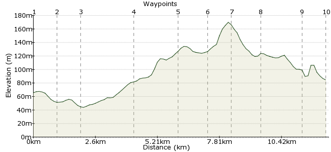
Ascent
124m (406ft)
Descent
104m (341ft)
Max. Elevation
170m (557ft)
Altitude Gain & Loss
228m (747ft)
Start & End
Ashton in Makerfield, Wigan, Lancashire, England
Distance
12.40km
(7.71mi)
(7.71mi)
Duration
~3:45h
Difficulty
Moderate
 7Created by ashtonkroz on 18 Sep 2012
A circular walk from Bryn Railway station to Billinge Hill through fields and lanes. With excellent views from the Billinge Beacon,
Walk Functions
Share
Nearby Walks
Carr Mill Dam from Ashton-in-Makerfield
A moderate, circular walk (countryside) starting in Greater Manchester, England, about 15.50km (9.63 mi) long, duration: ~4:30h.Field and canal around Pennington Flash
A moderate, circular walk (canal) starting in Greater Manchester, England, about 14.10km (8.76 mi) long, duration: ~4:00h.Circular walk using some of Sankey Valley Park
A moderate, circular walk (canal) starting in Greater Manchester, England, about 13.80km (8.57 mi) long, duration: ~4:00h.Walk Map
- $walk->POI array(0)
Waypoints
OS Grid SD571004
Leave the station and turn left and walk up to the traffic lights. Turn right and walk along the left side of the road for about 100m then take a path which goes off to the left to some playing fields. Keep to the left and take the path which carries on beyond the playing fields. Keep walking until you come to a lane.
OS Grid SD571013
when you reach this lane turn right and carry on for half a mile and then take a lane which leaves on the left. walk down this lane to a gate across the road near Park House Farm.
About 0.93 km (~0.58 miles) from 
OS Grid SD578021
Take the lane on the left and walk for half a mile until you reach the A49. Turn right and walk past the roundabout to the motorway and take a lane on the left just past the roundabout. keep on this lane for about half a mile passing through a Cranberry ley farm yard where the lane bears sharp left.
About 1.05 km (~0.65 miles) from 
OS Grid SD557019
carry on through the farmyard and take a footpath on the right after about 100m. This indistinct path leads in a NW direction to a stile at the end of a line of trees. Take the path which makes its way between the field fence and trees until you reach a new field. Turn left and follow the path round the edge of the field bearing right when you approach the motorway until you reach a tunnel under the M6. pass under the M6 then turn right and carry on past a farm to Ashton Road. When you reach Ashton Road turn left and take the public footpath across the field on the opposite side of the road. Keep on this path for about 500m until you meet a distinct path crossing on a field boundary . Turn right and keep going until you meet Wigan Road.
About 2.14 km (~1.33 miles) from 
OS Grid SD540014
When you reach this road take the path opposite which passes past a wood on your right. When you reach the end of the wood carry on for about 100m then bear right for 100m then left. Keep on this path until you arrive a Upholland road B5206. Turn right and carry on for about half a mile to the Post Office.
About 1.76 km (~1.09 miles) from 
OS Grid SD530021
Take the public footpath on the left just past the post office and keep on this path for about 300m then take a path on the left which makes its way up through a wood. Keep on this path until you reach the top then bear left and head for the top of Billinge Hill where you will see a square building.
About 1.24 km (~0.77 miles) from 
OS Grid SD524014
the top of Billinge hill has an old hunting lodge, now walled up, which is known as Billinge Beacon. There are now views over much of South Lancashire, Merseyside and even Wales on a good day. Take the path on the west side of the Beacon and walk down to a path which bears left. Keep on this path until you meet a road then turn left and carry on down this path onto Beacon road and into Billinge where you meet the A571 by an icecream parlour. Turn right and you will find 2 Pubs (Eagle and Child and The Stork)
About 0.94 km (~0.58 miles) from 
OS Grid SD532006
Take the B4207 opposite the Eagle and Child and carry on for about half a mile then take the public footpath signposted on your left. keep on this path which is a lane for about 200m and then becomes a path which takes you through a small wooded valley and across a footbridge. Carry on up to the corner of a small pine wood and then take the path on to the right along the front of the wood. You will soon meet a crossing path, by a field boundary, where you went up to Wigan Road earlier. Turn right here and make your way to Ashton Road.
About 1.12 km (~0.7 miles) from 
OS Grid SD548013
When you meet Ashton road turn right and take the public footpath on the left after about 100m. Keep on this path until you come to a lane by Brocstedes Farm. Turn left and follow the lane over the M6 motorway.
About 1.79 km (~1.11 miles) from 
 M6 bridge
OS Grid SD558013
Cross the M6 and keep on this lane which soon crosses the motorway slip road. Keep going until you meet a T junction turn left and carry on to the A49. Turn right and make your way back up a hill and through the traffic lights back to the station .
About 0.98 km (~0.61 miles) from 
