Field and canal around Pennington Flash
A moderate walk (canal) in Greater Manchester, England, about 14.10km (8.76 mi) long with an estimated walking time of about 4:00h. It is suitable for families with children, but unsuitable for prams & pushchairs, wheelchairs.
Elevation Profile
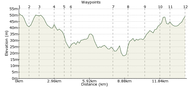
Ascent
33m (108ft)
Descent
36m (118ft)
Max. Elevation
60m (196ft)
Altitude Gain & Loss
69m (226ft)
Start & End
Ashton in Makerfield, Wigan, Lancashire, England
Distance
14.10km
(8.76mi)
(8.76mi)
Duration
~4:00h
Difficulty
Moderate
Ordnance Survey Maps
 7Created by ashtonkroz on 20 Sep 2012
A circular walk from Ashton-in-Makerfield bus stop, around Pennington Flash via the Leeds-Liverpool canal. The walk passes through fields, lanes and reclaimed parks created on old industrial land.
Walk Functions
Share
Nearby Walks
Circular walk using some of Sankey Valley Park
A moderate, circular walk (canal) starting in Greater Manchester, England, about 13.80km (8.57 mi) long, duration: ~4:00h.Carr Mill Dam from Ashton-in-Makerfield
A moderate, circular walk (countryside) starting in Greater Manchester, England, about 15.50km (9.63 mi) long, duration: ~4:30h.Billinge Hill from Bryn Station
A moderate, circular walk (countryside) starting in Greater Manchester, England, about 12.40km (7.71 mi) long, duration: ~3:45h.Walk Map
- $walk->POI array(0)
Waypoints
OS Grid SJ578991
Leave the bus stop and walk along Princess Road (opposite Barclays Bank). When the road bends sharply right, continue straight on a path into a bushy area. Take the path on the left and after about 100m, take the path on the right behind some new houses. Keep going for another 100m to the end of a street (Lincoln Drive).
OS Grid SJ587991
Carry straight on along a path behind some more houses, which leads to a wooded area (this was once a sewage farm but has been now been planted with trees). Keep straight on until you come to some open fields. Take the path straight ahead between the open fields, then the path which leads left at the end of the field and walk to an open grassy area. Head for the opposite corner of this area and take a path through some trees which leads to Edge Green Lane, coming out behind a bus stop.
About 0.86 km (~0.53 miles) from 
OS Grid SJ595988
Turn left and walk up to the junction with Golborne Road. Cross with care and take a public footpath straight ahead, which leads down the left of a bungalow. Keep on this path until you come out on Edge Green Road, on the corner of Dam Lane. Walk along Edge Green Road for about half a mile past the Harrow Inn. About 50m past the pub, take a footpath on the right into Locker Lane Farm.
About 0.83 km (~0.52 miles) from 
OS Grid SJ598999
Take the path through the farmyard, keeping to the right (the Alsatian on a strong chain is on the left!). Keep on the track which leads past a caravan storage yard to Viridor Wood - a park made on the site of an old colliery. About 300m past the farm, pass through a gate and then take the well-surfaced path straight ahead. Keep on this path which rises up to some wooden sculptures. About 200m past the sculptures, take the path on the right which carries on for about 400m to a railway bridge.
About 1.10 km (~0.68 miles) from 
OS Grid SD602007
Pass under the bridge and take the path straight ahead. Keep on this path, which crosses a wet area on a set of duck boards. Carry straight ahead until you arrive near a pub (the Dover Lock). Cross a footbridge over a small river behind the pub and walk up to the road.
About 0.86 km (~0.53 miles) from 
OS Grid SD607007
Cross the road with care, turn right and join the canal towpath on your left. Follow this towpath for approx. 2km passing under two bridges and crossing a road by a small marina. Keep on the towpath for about 500m past the marina until you meet a footbridge across the canal.
About 0.54 km (~0.34 miles) from 
OS Grid SJ640996
Take the path on your right down to Pennington Flash Country Park. The park is on the site of an old colliery and the wetland has been formed because of subsidence from old mine workings. Walk straight ahead for about 400m until you come to car park next to the lake. Keep walking clockwise on the path round the lake; you will eventually pass through a farmyard and come out onto a road with a yacht club on your right.
About 3.45 km (~2.14 miles) from 
OS Grid SJ631987
Turn right and carry on round the road, Byrom Lane, which bends round to the left. Carry on to the T-junction and turn left onto Slag Lane. Cross over the road and take a path after the bus stop which leads through a yard and into Byrom Wood, behind Byrom Hall. After about 50m, take the right-hand path and follow the well-made track round the planted area. Follow the path round to the left and, after about 150m, look out for a small path leading off to the right to a gate approx. 30m ahead.
About 1.25 km (~0.78 miles) from 
OS Grid SJ619990
Pass through the gate and over a footbridge across a small stream and turn left. Keep on this path for about 750m until you pass through a farmyard onto Lowton Road.
About 1.26 km (~0.78 miles) from 
OS Grid SJ609984
Turn right and walk about 100m to a mini roundabout. Turn left and after 100m, turn right onto Poplar Street. Cross the footbridge over the railway and enter the park, made on the site of the old Golborne colliery. Where the path forks left and right, take the left path up a small rise. Carry on crossing one path and down to the junction with the next path. Turn right here and carry on for about 100m until you can seen a children's play area on your left. Turn left here and leave the park after 100m onto Walters Green Crescent. Cross over onto the public footpath straight ahead, which leads to Edge Green Lane near an Asda store.
About 1.22 km (~0.76 miles) from 
OS Grid SJ600984
Turn right here and walk for about 200m until you can see a Chinese takeaway on your right. Turn right here and follow the track past some garages to a disused railway line. Turn left and follow the path of the railway for about 1km. When you reach the end of the track, turn right through a gate to Ashton Heath.
About 0.88 km (~0.55 miles) from 
 Ashton Heath
OS Grid SJ587984
Immediately after leaving the railway track through the gate, turn left and follow the path for about 30m, then take a path on the right. Carry on this path to the end of the heath, then walk down Heath Road for about 400m, passing two pubs, the Hingemakers Arms and the Commercial Inn. Take the next right after the Commercial Inn down Butchers Lane, which takes you back to Gerrard Street for your bus home.
About 1.29 km (~0.8 miles) from 

1 comment... join the discussion!
Peter O
Did this walk today 13/4/2013 with a companion who checked progress and overall distance with GPS device.It measured 12.1 miles not 8 ! Pleasant walk,mainly but not all on the flat. Think not suitable for young children due to distance and need to cross old railway bridge in poor state or repair(part of walkway missing and deep drop)Good facilities at Pennington Flash car park (Toilets, Information, Tea/Food Van and ice cream van.)