Nidderdale and Brimham Rocks
A leisurely walk (riverside) in North Yorkshire, England, about 11.00km (6.84 mi) long with an estimated walking time of about 3:45h. It is suitable for families with children, but unsuitable for prams & pushchairs, wheelchairs.
Elevation Profile
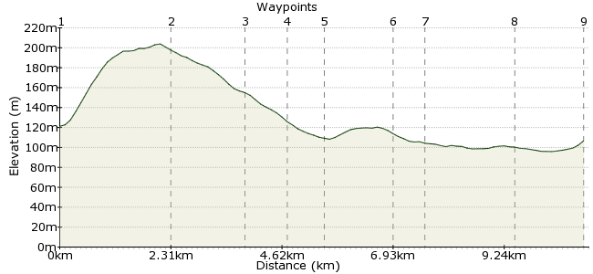
Ascent
214m (702ft)
Descent
193m (633ft)
Max. Elevation
210m (688ft)
Altitude Gain & Loss
407m (1335ft)
Start & End
Pateley Bridge
Distance
11.00km
(6.84mi)
(6.84mi)
Duration
~3:45h
Difficulty
Leisurely
Ordnance Survey Map
The Nidderdale Valley is an area of outstanding natural beauty just outside the Yorkshire Dales. One of the region's highlights is Brimham Rocks, an area of dramatic rock formations set in beautiful moorland. It's well worth making a day of this short walk to allow time to explore them.
Return via the River Nidd for an easy finish to the day.
Walk Functions
Share
Nearby Walks
The western side of Nidderdale
A moderate, linear walk (low hills and fells (below 600m)) starting in North Yorkshire, England, about 11.70km (7.27 mi) long, duration: ~4:00h.Bolton Abbey Circular via Simon's Seat
A moderate, circular walk (low hills and fells (below 600m)) starting in North Yorkshire, England, about 15.20km (9.44 mi) long, duration: ~5:15h.Ripon to Fountains Abbey and Studley park
A moderate, walk (countryside) starting in North Yorkshire, England, about 11.50km (7.15 mi) long, duration: ~3:30h.Walk Map
- $walk->POI array(0)
Waypoints
OS Grid SE158655
Take the bus to Pateley Bridge.
OS Grid SE182650
Follow the Nidderdale Way to Blazefield, heading east out of town.
About 2.40 km (~1.49 miles) from 
OS Grid SE196653
At Mill House, leave the Nidderdale Way to head towards Brimham Rocks.
About 1.47 km (~0.91 miles) from 
OS Grid SE205652
Allow a bit of time to explore Brimham Rocks, managed by the National Trust. It's a great place for some scrambling about on the rocks, or just lazing on top of them if it's sunny. More info here: www.nationaltrust.org.uk/brimham-rocks
About 0.89 km (~0.55 miles) from 
OS Grid SE207645
At High Woods, pick up the footpath that will return you to the Nidderdale Way.
About 0.77 km (~0.48 miles) from 
OS Grid SE194642
Pass through Smelthouses back into Nidderdale.
About 1.34 km (~0.83 miles) from 
OS Grid SE188638
Pass through Knox Hall to join the footpath along the River Nidd.
About 0.65 km (~0.4 miles) from 
OS Grid SE171643
It's a pleasant riverside walk back towards Pateley Bridge.
About 1.79 km (~1.11 miles) from 
 Pateley Bridge again
OS Grid SE160654
Finish up back in Pateley Bridge for the bus home.
About 1.50 km (~0.93 miles) from 
