Great Whernside and Cam Head
A moderate walk (low hills and fells (below 600m)) in national park Yorkshire Dales in North Yorkshire, England, about 11.20km (6.96 mi) long with an estimated walking time of about 4:45h. It is unsuitable for families with children, prams & pushchairs, wheelchairs.
Elevation Profile
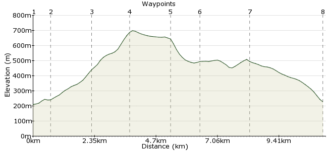
Ascent
502m (1646ft)
Descent
484m (1587ft)
Max. Elevation
700m (2296ft)
Altitude Gain & Loss
986m (3233ft)
Start & End
Kettlewell
Distance
11.20km
(6.96mi)
(6.96mi)
Duration
~4:45h
Difficulty
Moderate
Ordnance Survey Map
This walk starts and finishes in Kettlewell, Upper Wharfedale. Right on the boundary of the Yorkshire Dales, it's a good day out and Kettlewell is a fine walkers' base, with good pubs and shops. The summits are quite high but easy going, making it a good 'starter' hill for kids.
Walk Functions
Share
Nearby Walks
Cam Head and Buckden Pike
A moderate, circular walk (low hills and fells (below 600m)) starting in North Yorkshire, England, about 16.10km (10.00 mi) long, duration: ~6:00h.Buckden Circular
A moderate, circular walk (countryside) starting in North Yorkshire, England, about 10.50km (6.52 mi) long, duration: ~3:15h.Bucken Circular - Up and Over & Return
A moderate, circular walk (low hills and fells (below 600m)) starting in North Yorkshire, England, about 16.90km (10.50 mi) long, duration: ~6:45h.Walk Map
- $walk->POI array(0)
Waypoints
OS Grid SD968722
Start the walk in Kettlewell.
OS Grid SD975725
The footpath to Hag Dyke leaves from the northern end of the village.
About 0.69 km (~0.43 miles) from 
OS Grid SD989732
After climbing steeply through the fields, you reach Hag Dyke hostel, high up on the hillside.
About 1.59 km (~0.99 miles) from 
OS Grid SE002738
Cross the boggy land above Hag Dyke to reach the rocky summit of Great Whernside.
About 1.41 km (~0.88 miles) from 
OS Grid SD996752
Follow the summit ridge north to the secondary summit of Whernside.
About 1.46 km (~0.91 miles) from 
OS Grid SD986756
Cross the road at the cattle grid. Take the chance to peek into little-visited Coverdale.
About 1.14 km (~0.71 miles) from 
OS Grid SD969752
Follow the path around the edge of the hill to Cam Head.
About 1.71 km (~1.06 miles) from 
 Back to Kettlewell
OS Grid SD972723
It's a straight path down Cam Pasture back into Kettlewell. Lots to do here, including visiting the village shop and the pubs while you wait for the Dalesbus home.
About 2.85 km (~1.77 miles) from 
