Mynydd Islwyn and Sirhowy Valley Park
A moderate walk (countryside) in Gwent, UK, about 15.40km (9.57 mi) long with an estimated walking time of about 6:00h. It is unsuitable for families with children, prams & pushchairs, wheelchairs.
Elevation Profile
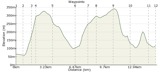
Ascent
552m (1811ft)
Descent
502m (1646ft)
Max. Elevation
0m (0ft)
Altitude Gain & Loss
1054m (3457ft)
Start & End
Crosskeys
Distance
15.40km
(9.57mi)
(9.57mi)
Duration
~6:00h
Difficulty
Moderate
Ordnance Survey Maps
This walk explores some of the paths around the lower reaches of Ebbw Vale. Starting at Crosskeys, the route climbs the hill south of the town to Sirhowy Valley Country Park. Then it's north over Mynydd Islwyn, a small village on the hill, before finishing at Newbridge. Both towns are on the Ebbw Vale Line.
You can find out a bit more about the Country Park here: http://your.caerphilly.gov.uk/countryside/country-parks/sirhowy-valley-country-park
Walk Functions
Share
Nearby Walks
Taff and Ely Circular
A leisurely, linear walk (riverside) starting in Cardiff, Wales, about 6.70km (4.16 mi) long, duration: ~1:45h.Oriel Canfas
A leisurely, circular walk (city/town) starting in Cardiff, Wales, about 4.80km (2.98 mi) long, duration: ~1:15h.Cardiff City
A leisurely, circular walk (city/town) starting in Cardiff, Wales, about 6.90km (4.29 mi) long, duration: ~2:00h.Walk Map
- $walk->POI array(0)
Waypoints
OS Grid ST220919
Start the walk in Crosskeys, on the Ebbw Vale line.
OS Grid ST225912
Walk through the town and head under the main road via the underpass at Blackvein Road.
About 0.89 km (~0.55 miles) from 
OS Grid ST222906
A zigzag road takes you uphill through the woods.
About 0.71 km (~0.44 miles) from 
OS Grid ST218905
At the top of the hill, you reach the Sirhowy Valley Path.
About 0.48 km (~0.3 miles) from 
OS Grid ST199904
Where the footpath meets the road again, start dropping downhill along the footpath.
About 1.81 km (~1.12 miles) from 
OS Grid ST177908
Continue along the ridge to Mynydd y Grug.
About 2.32 km (~1.44 miles) from 
OS Grid ST173921
Beyond the summit, drop into the woods down the hillside.
About 1.31 km (~0.81 miles) from 
OS Grid ST179926
Drop into the valley and cross the river at Ynysddu. Then continue up the opposite hillside.
About 0.85 km (~0.53 miles) from 
OS Grid ST193939
Follow the footpaths to Mynyddislwyn on the crest of the hill. This is an interesting little place with a lot of history: www.oakdalevillage.net/history5.html
About 1.83 km (~1.14 miles) from 
OS Grid ST211942
Drop down into the woods around Abercarn, where you can follow the lower track heading north.
About 1.82 km (~1.13 miles) from 
OS Grid ST212961
Continue along the forest track to the outskirts of Newbridge.
About 1.92 km (~1.19 miles) from 
 Ebbw View Terrace
OS Grid ST209968
Join the road that heads under the main road and into Newbridge.
About 0.77 km (~0.48 miles) from 

2 comments... join the discussion!
Tim Woods
Hi Geraint, that's fixed now, thanks for spotting.
Tim
Geraint
Hi, just would like to point out that this walk is listed as in Pembrokeshire it is not, it's in Gwent. look up for the individual new county.
regards
Geraint