Moelfre
A leisurely walk (coast) in Isle of Anglesey, Wales, about 6.10km (3.79 mi) long with an estimated walking time of about 1:45h. It is suitable for families with children, but unsuitable for prams & pushchairs, wheelchairs.
Elevation Profile
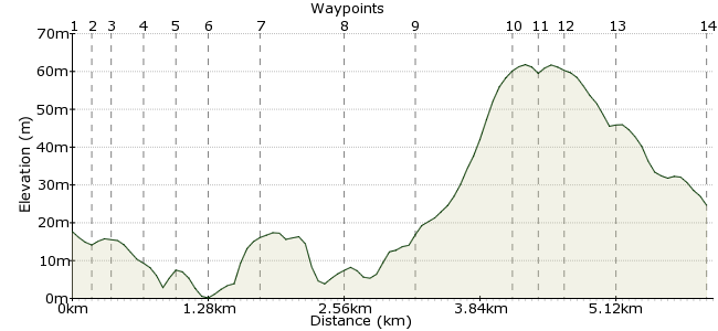
Ascent
67m (219ft)
Descent
60m (196ft)
Max. Elevation
70m (229ft)
Altitude Gain & Loss
127m (415ft)
Start & End
Moelfre
Distance
6.10km
(3.79mi)
(3.79mi)
Duration
~1:45h
Difficulty
Leisurely
Ordnance Survey Map
 1Created by driver 16 on 22 May 2013
A cliff top and fields walk on Anglesey, and a chance to get up close and personal with some RNLI lifeboats. One is anchored in the bay, awaiting the building of a new station after two years of planning submissions. Make sure you visit the ruined 12th century chapel and the 4th century hut group and burial chamber. Children must be supervised, especially on cliffs above Lligwy Bay.
Walk Functions
Share
Nearby Walks
Mynydd Bodafon
A leisurely, linear walk (low hills and fells (below 600m)) starting in Isle of Anglesey, Wales, about 8.90km (5.53 mi) long, duration: ~2:45h.Amlwch to Llaneilian
A leisurely, circular walk (coast) starting in Isle of Anglesey, Wales, about 8.20km (5.10 mi) long, duration: ~2:30h.Llangefni - the Dingle Llyn Cefni & Oriel Ynys Mon
A leisurely, circular walk (countryside) starting in Isle of Anglesey, Wales, about 6.50km (4.04 mi) long, duration: ~2:00h.Walk Map
- $walk->POI array(0)
Waypoints
OS Grid SH511862
On alighting, look right to see a fingerpost in the direction of the beach. Follow the road down to the beach.
OS Grid SH512863
Follow the road uphill with the sea on your right. Where the road bears left, then turn right onto the lane above the sea. You can see the new class lifeboat anchored in the bay.
About 0.16 km (~0.1 miles) from 
OS Grid SH513864
Outside there are features dedicated to the wrecking of the Royal Charter and coxwain Dic Evans, 1905-2001. Inside is an old lifeboat, 'Bird's Eye', and a shop.
About 0.13 km (~0.08 miles) from 
OS Grid SH515865
Visitors are allowed inside and used to be able to see the boat 'Robert and Violet', but it recently went to Ireland. You may be able to chat to members of the crew if they are on station.
About 0.21 km (~0.13 miles) from 
OS Grid SH516867
Ignore signs pointing inland, and pass to the right and behind the cottages on the path looking over Ynys Moelfre (an island). Follow this to a new architectural / art feature with seating.
About 0.26 km (~0.16 miles) from 
OS Grid SH514868
Go down, keeping to the right of the stone wall, and follow this to the memorial to the sinking of the Royal Charter.
About 0.23 km (~0.14 miles) from 
OS Grid SH509869
Visit the memorial, then back to the path, which you follow to Porth Forllwyd.
About 0.49 km (~0.3 miles) from 
OS Grid SH502872
Turn right past a house called Moryn, then follow the edge of a field. Turn left onto a path with hedges on both sides above Lligwy beach. Watch carefully if you have children. Exit into the car park and turn left.
About 0.71 km (~0.44 miles) from 
OS Grid SH496870
Follow the road out, straight across the junction, then follow the road to see an old chapel site on your right (it's well signed).
About 0.67 km (~0.42 miles) from 
OS Grid SH499862
The chapel is easy to see on your right; the village is through the trees on your left. After visiting, retrace your steps to the road and turn right to go to the burial chamber. Pass the campsite on the bend in the road and keep going right.
About 0.83 km (~0.52 miles) from 
OS Grid SH501860
After visiting, turn left onto the road back towards the old chapel, but just beforehand look on your right for a footpath sign and stile in the hedge.
About 0.26 km (~0.16 miles) from 
OS Grid SH500862
Cross the field; there may be cows and if with calves, beware as they can attack to defend their young. If it's just adults, you should be OK. Exit onto the road by a quarry.
About 0.18 km (~0.11 miles) from 
OS Grid SH502866
Stay on the road, pass the school, then back to the bus stop.
About 0.40 km (~0.25 miles) from 
 Bus stop
OS Grid SH510864
End of the walk. It's very pleasant with loads of history, spectacular views, another one to recommend. Enjoy!
About 0.82 km (~0.51 miles) from 
