Arun Valley Amble
A moderate walk (riverside) starting and finishing in West Sussex, England, about 17.90km (11.12 mi) long with an estimated walking time of about 5:15h. It is unsuitable for families with children, prams & pushchairs, wheelchairs.
Elevation Profile
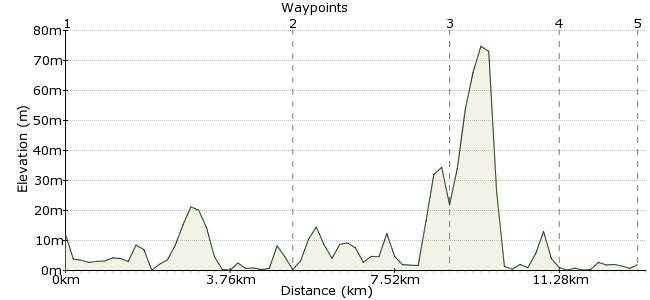
Ascent
2m (6ft)
Descent
12m (39ft)
Max. Elevation
80m (262ft)
Altitude Gain & Loss
14m (45ft)
Start
Pulborough
End
Littlehampton
Distance
17.90km
(11.12mi)
(11.12mi)
Duration
~5:15h
Difficulty
Moderate
Ordnance Survey Map
 Car Free Walks TeamCreated by GaryShipp on 25 Aug 2007
Follow the banks of the lovely River Arun. Start at Mean High Water near Pulborough and follow the route of the Wey South Path to Amberley. If the legs are willing, then onwards to Arundel, then Littlehampton and the sea.
Walk Functions
Share
Nearby Walks
The Arun valley
A leisurely, linear walk (riverside) starting in West Sussex, England, about 9.20km (5.72 mi) long, duration: ~2:45h.Around Amberley
A moderate, circular walk (countryside) starting in West Sussex, England, about 14.90km (9.26 mi) long, duration: ~4:45h.The heart of the Downs
A strenuous, linear walk (countryside) starting in West Sussex, England, about 26.50km (16.47 mi) long, duration: ~9:00h.Walk Map
- $walk->POI array(0)
Waypoints
OS Grid TQ042185
Start of the walk
OS Grid TQ026116
If the legs are tired, or you stayed just a bit too long in the pub! Otherwise it's time to decide on the left or right hand side backs of the river as the next crossing point is some way away. The Western bank offers a lovely walk along the edge of the Castle grounds and Wildfowl Centre.
About 7.13 km (~4.43 miles) from 
OS Grid TQ019069
Take a closer look at the town of Arundel if you've time. Or make time. The station is a short stroll out of town if you've reached the end of your day.
About 4.71 km (~2.93 miles) from 
OS Grid TQ004041
A gentle stroll down the banks of the river will take you to Ford and another option to end your day with a train journey home.
About 3.26 km (~2.03 miles) from 
 The last bridge
OS Grid TQ022022
It's worth a detour to the beach if you've both the time and the inclination. Otherwise the station is a stones throw from the bridge.
About 2.57 km (~1.6 miles) from 

1 comment... join the discussion!
Timwoods
This walk joins another Car Free Walk halfway - 'The heart of the Downs - Goring-by-Sea to Amberley'. Instead of carrying straight on to Arundel, you can turn off at Amberley and follow the South Downs way. This is a pleasant diversion, especially if you have to head towards Brighton anyway for your transport home.