Eltermere to Coniston via The Old Man
A moderate walk (mountain (above 600m)) starting and finishing in Cumbria, England, about 14.40km (8.95 mi) long with an estimated walking time of about 6:15h. It is unsuitable for families with children, prams & pushchairs, wheelchairs.
Elevation Profile
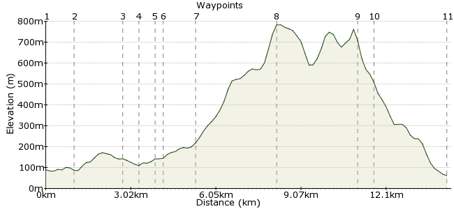
Ascent
726m (2381ft)
Descent
753m (2470ft)
Max. Elevation
790m (2591ft)
Altitude Gain & Loss
1479m (4851ft)
Start
Brittannia Inn, Elterwater
End
Coniston
Distance
14.40km
(8.95mi)
(8.95mi)
Duration
~6:15h
Difficulty
Moderate
Tough, high-level linear walk between two of the most picturesque villages in the Lake District. Not for the faint hearted!
Walk Functions
Share
Nearby Walks
Helm Crag & The Lion and the Lamb
A moderate, circular walk (low hills and fells (below 600m)) starting in Cumbria, England, about 10.30km (6.40 mi) long, duration: ~4:15h.A lakeland stroll to Easedale Tarn
A leisurely, circular walk (low hills and fells (below 600m)) starting in Cumbria, England, about 6.20km (3.85 mi) long, duration: ~2:15h.Grasmere to Ravenglass
A hard, linear walk (mountain (above 600m)) starting in Cumbria, England, about 33.60km (20.88 mi) long, duration: ~13:45h.Walk Map
- $walk->POI array(0)
Waypoints
OS Grid NY321053
Start the walk from the Langdale Timeshare Estate
OS Grid NY326044
Take right turn up track opposite Eltermere Inn
About 1.09 km (~0.68 miles) from 
OS Grid NY313034
Follow path over Slaters Bridge
About 1.65 km (~1.03 miles) from 
OS Grid NY311029
Go through kissing gate and turn right along track to walking cottages
About 0.57 km (~0.35 miles) from 
OS Grid NY306027
Bear right as track joins from Tilberthwaite (from left)
About 0.51 km (~0.32 miles) from 
OS Grid NY305028
Take track to left to Greenburn with burn on your right
About 0.19 km (~0.12 miles) from 
OS Grid NY295023
Turn right off track and cross burn. Go up opposite bank and take the path up the fell onto
About 1.10 km (~0.68 miles) from 
OS Grid NY272005
Continue up Wet Side Edge over Hell Ghyll onto Swirl How
About 2.88 km (~1.79 miles) from 
OS Grid SD272978
From Swirl How take path (South) onto the Old Man of Coniston
About 2.71 km (~1.68 miles) from 
OS Grid SD275982
Descend with care to Low Water
About 0.51 km (~0.32 miles) from 
 Coniston Village
OS Grid SD302976
Take path from Low Water to Coniton
About 2.69 km (~1.67 miles) from 
