The Arun valley
A leisurely walk (riverside) in national park South Downs starting and finishing in West Sussex, England, about 9.20km (5.72 mi) long with an estimated walking time of about 2:45h. It is suitable for families with children, but unsuitable for prams & pushchairs, wheelchairs.
Elevation Profile
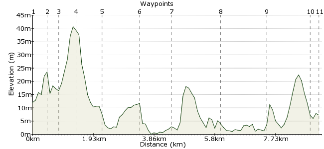
Ascent
40m (131ft)
Descent
45m (147ft)
Max. Elevation
50m (164ft)
Altitude Gain & Loss
85m (278ft)
Start
Pulborough
End
Houghton Bridge, Amberley
Distance
9.20km
(5.72mi)
(5.72mi)
Duration
~2:45h
Difficulty
Leisurely
Ordnance Survey Map
This walk between Pulborough and Amberley follows the River Arun as it heads south. It can be done in either direction but starting at Pulborough gives you views of the South Downs as you walk. Allow time to explore/enjoy at least one of the RSPB reserve, the museum in Amberley or the Riverside Tea Rooms near Amberley Station.
Walk Functions
Share
Nearby Walks
Arun Valley Amble
A moderate, linear walk (riverside) starting in West Sussex, England, about 17.90km (11.12 mi) long, duration: ~5:15h.Around Amberley
A moderate, circular walk (countryside) starting in West Sussex, England, about 14.90km (9.26 mi) long, duration: ~4:45h.The heart of the Downs
A strenuous, linear walk (countryside) starting in West Sussex, England, about 26.50km (16.47 mi) long, duration: ~9:00h.Walk Map
- $walk->POI array(0)
Waypoints
OS Grid TQ041186
Start the walk in Pulborough, on the edge of the South Downs.
OS Grid TQ045188
Take the path heading left out of the station, then turn left again at Church Place to cross the railway track.
About 0.46 km (~0.29 miles) from 
OS Grid TQ042189
Take the first path on the left after the railway.
About 0.34 km (~0.21 miles) from 
OS Grid TQ037189
The path connects to the Wey-South Path, which then takes you north along the valley.
About 0.50 km (~0.31 miles) from 
OS Grid TQ032182
Cross the road at Stopham, then two bridges over the river.
About 0.86 km (~0.53 miles) from 
OS Grid TQ032171
Pass the remains of the 12th century Hardham Priory.
About 1.14 km (~0.71 miles) from 
OS Grid TQ031162
Continue to Greatham Bridge on the northern side of the nature reserve.
About 0.92 km (~0.57 miles) from 
OS Grid TQ030147
The path continues through Amberley Wild Brooks, a floodplain rich in birdlife and an RSPB reserve: www.rspb.org.uk/discoverandenjoynature/seenature/reserves/guide/a/amberleywildbrooks
About 1.44 km (~0.89 miles) from 
OS Grid TQ030132
The path continues south into the village of Amberley, just to the north of the South Downs.
About 1.49 km (~0.93 miles) from 
OS Grid TQ027119
There is a great museum in Amberley, if you have time:
www.amberleymuseum.co.uk
About 1.31 km (~0.81 miles) from 
 Amberley station
OS Grid TQ026118
Continue along the road (there is a footpath to keep you away from traffic) to the station. Head to the Riverside Tea Rooms for some food before heading home: http://dinebytheriver.co.uk
About 0.25 km (~0.16 miles) from 
