Snowdon traverse - South to North
A moderate walk (mountain (above 600m)) in national park Snowdonia starting and finishing in Gwynedd, Wales, about 15.30km (9.51 mi) long with an estimated walking time of about 7:15h. It is unsuitable for families with children, prams & pushchairs, wheelchairs.
Elevation Profile
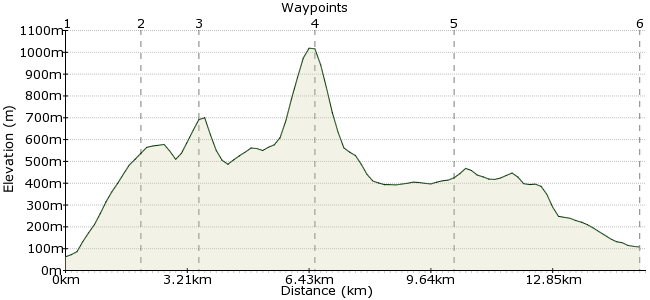
Ascent
968m (3175ft)
Descent
923m (3028ft)
Max. Elevation
1020m (3346ft)
Altitude Gain & Loss
1891m (6203ft)
Start
Beddgelert bus stop
End
Llanberis
Distance
15.30km
(9.51mi)
(9.51mi)
Duration
~7:15h
Difficulty
Moderate
Ordnance Survey Map
This is a great way to tackle Snowdon and appreciate the size of this amazing mountain! By doing a linear route you avoid having to back track, getting to see much more of the region in the process! You can reach the start and finish points using the Sherpa Bus which serves the region.
Walk Functions
Share
Nearby Walks
Exploring the history around Beddgelert
A leisurely, circular walk (low hills and fells (below 600m)) starting in Gwynedd, Wales, about 7.60km (4.72 mi) long, duration: ~2:45h.Moel Hebog, Moel yr Ogof and Moel Lefn
A moderate, circular walk (mountain (above 600m)) starting in Gwynedd, Wales, about 9.50km (5.90 mi) long, duration: ~4:30h.Snowdon's southern ridge
A moderate, circular walk (mountain (above 600m)) starting in Gwynedd, Wales, about 10.80km (6.71 mi) long, duration: ~5:45h.Walk Map
- $walk->POI array(0)
Waypoints
OS Grid SH593484
Start from the small town of Beddgelert, heading along the A498 until you see a footpath on the left hand side of the road.
OS Grid SH594505
Follow the path and pick up the track heading uphill to Craig Wen.
About 2.10 km (~1.3 miles) from 
OS Grid SH605515
Head Northeast from the summit of Craig Wen to Yr Aran.
About 1.48 km (~0.92 miles) from 
OS Grid SH609544
From Yr Aran, head along the Clogwyn Du ridge and join the masses of daytrippers at Snowdon summit. There is due to be a new cafe opening here, hopefully nicer than the last one.
About 2.93 km (~1.82 miles) from 
OS Grid SH573556
From the summit, avoid the overcrowded Llanberis path and take the Snowdon Ranger path down. At this grid reference, take the path heading north past Foel Goch (otherwise you have a long walk round to Llanberis!)
About 3.78 km (~2.35 miles) from 
 Llanberis
OS Grid SH578604
The path heads north across open land before reaching the farmland outside Llanberis, where you can choose your own route amongst the many paths. No trip to Llanberis is complete without a stop at Pete's Eats, the legendary climber's cafe (where they serve tea in pints!)
About 4.82 km (~3 miles) from 
