Steyning and Cissbury Ring
A leisurely walk (low hills and fells (below 600m)) in national park South Downs starting and finishing in West Sussex, England, about 7.10km (4.41 mi) long with an estimated walking time of about 2:30h. It is unsuitable for families with children, prams & pushchairs, wheelchairs.
Elevation Profile
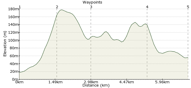
Ascent
183m (600ft)
Descent
144m (472ft)
Max. Elevation
180m (590ft)
Altitude Gain & Loss
327m (1072ft)
Start
Steyning clock tower
End
Findon High street
Distance
7.10km
(4.41mi)
(4.41mi)
Duration
~2:30h
Difficulty
Leisurely
Ordnance Survey Maps
A quieter section of the South Downs, and all the better for it. Brighton and Hove buses take you to the village of Steyning, from where it's Downs all the way to the village of Findon.
Walk Functions
Share
Nearby Walks
Devil's Dyke to Stanmer Park - a South Downs classic
A moderate, linear walk (low hills and fells (below 600m)) starting in East Sussex, England, about 11.50km (7.15 mi) long, duration: ~3:45h.The heart of the Downs - Goring-by-Sea to Amberley
A moderate, linear walk (low hills and fells (below 600m)) starting in West Sussex, England, about 13.10km (8.14 mi) long, duration: ~4:00h.South Downs Way: Pyecombe to Upper Beeding
A moderate, linear walk (low hills and fells (below 600m)) starting in West Sussex, England, about 11.30km (7.02 mi) long, duration: ~3:45h.Walk Map
- $walk->POI array(0)
Waypoints
OS Grid TQ174113
Start of the walk
OS Grid TQ163102
From the village, take the path heading out to Round Hill and continue up to the top, where the South Downs Way meets the Monarch's Way.
About 1.53 km (~0.95 miles) from 
OS Grid TQ151097
Don't go along the South Downs, but head along the Monarch's Way to No Man's Land Valley - it's a nice quiet spot.
About 1.35 km (~0.84 miles) from 
OS Grid TQ135079
From the Monarch's Way, take the path due south to Cissbury Ring. This is a huge hillfort, the biggest in Sussex during the Iron Age, and now owned by the National Trust.
About 2.39 km (~1.49 miles) from 
 Findon
OS Grid TQ120087
Finish up in Findon, where you will find a pub and buses back to Worthing and Brighton.
About 1.70 km (~1.06 miles) from 

4 comments... join the discussion!
Timwoods
Hi Tammy, yes they are well marked and fine for running, although the South Downs is chalky and gets slippery after rain.
Tammy
Are these routes marked out, and are they suitable for running? Thank you.
Timwoods
Hi Grace No one to contact - the walks here are almost all unguided walks. This one is pretty straightforward so you won't get lost! You can use our search facility to find walks near Horsham - there are quite a few! Tim
Grace Williams
I would be very interested in the above walk Steyning and Cissbury Ring. Who do I contact please! I live in Horsham but sure there is a bus to Steyning. thanks. 07580378404 Love walking. Maybe you have some near me in Southwater??