Y Fal - the Sugar Loaf
A leisurely walk (low hills and fells (below 600m)) in Monmouthshire (Sir Fynwy), Wales, about 9.20km (5.72 mi) long with an estimated walking time of about 4:00h. It is unsuitable for families with children, prams & pushchairs, wheelchairs.
Elevation Profile
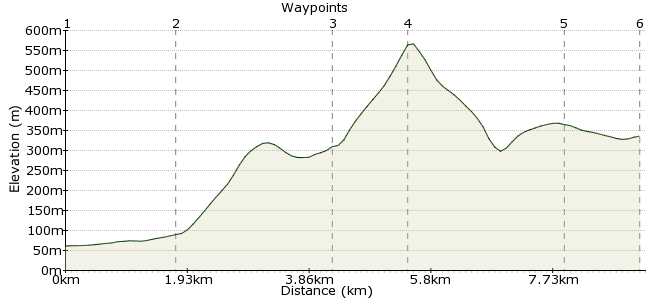
Ascent
507m (1663ft)
Descent
232m (761ft)
Max. Elevation
570m (1870ft)
Altitude Gain & Loss
739m (2424ft)
Start & End
Abergavenny
Distance
9.20km
(5.72mi)
(5.72mi)
Duration
~4:00h
Difficulty
Leisurely
Ordnance Survey Map
This walk is perfect for those who like their hills easily accessible. Y Fal , known as Sugar Loaf in English, is a small hill just outside the town of Abergavenny in South Wales. It makes a great half day walk, with breathtaking views of Abergavenny and the Black Mountains from the summit. Abergavenny is an interesting town as well, with a ruined castle, and a useful stop off en route to the Brecon Beacons or the Black Mountains.
Walk Functions
Share
Nearby Walks
The Vale of Ewyas from Abergavenny
A strenuous, circular walk (low hills and fells (below 600m)) starting in Monmouthshire (Sir Fynwy), Wales, about 33.40km (20.75 mi) long, duration: ~13:45h.Sugar Plum Fairy
A moderate, circular walk (low hills and fells (below 600m)) starting in Monmouthshire (Sir Fynwy), Wales, about 18.40km (11.43 mi) long, duration: ~6:45h.The Skirrid from Pandy
A moderate, circular walk (low hills and fells (below 600m)) starting in Monmouthshire (Sir Fynwy), Wales, about 10.00km (6.21 mi) long, duration: ~3:45h.Walk Map
- $walk->POI array(0)
Waypoints
OS Grid SO297145
The walk starts in the town of Abergavenny, which is well served by trains and buses. Head towards Chapel Mill Farm on the northwest edge of the town.
OS Grid SO282154
From Chapel Mill Farm, follow the road heading West to Orchard House, home of the Sugar Loaf vineyards - not really what you expect to find in South Wales!
About 1.80 km (~1.12 miles) from 
OS Grid SO270175
Follow the road heading Northwest past Pentre Farm and pick up one of the footpaths heading through the woods in St Mary's Vale. Carry on to Cwm Trosnant.
About 2.42 km (~1.5 miles) from 
OS Grid SO273187
Once you are clear of the woods, the route to the summit is easy - just follow the paths leading uphill.
About 1.17 km (~0.73 miles) from 
OS Grid SO293174
It's worth extending the walk to take in this smaller summit to the east - follow the path around the top of the woodland and continue along the top to Deri.
About 2.44 km (~1.52 miles) from 
 Twyn-yr-allt
OS Grid SO296164
The footpath drops off the end of Deri and rejoins the road near Chapel Mill Farm. From here, walk back into Abergavenny.
About 1.12 km (~0.7 miles) from 
