Sheringham walk
A moderate walk (countryside) in Norfolk, England, about 9.60km (5.97 mi) long with an estimated walking time of about 3:00h. It is unsuitable for families with children, prams & pushchairs, wheelchairs.
Elevation Profile
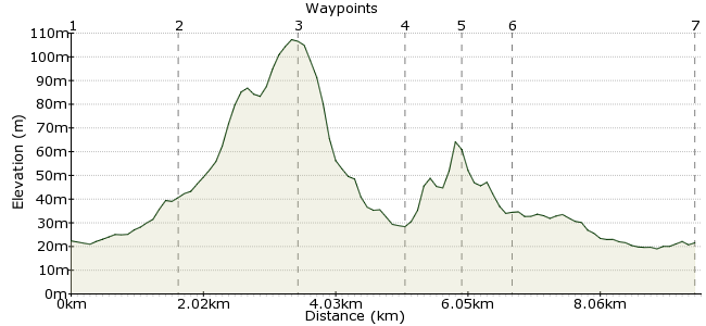
Ascent
120m (393ft)
Descent
121m (396ft)
Max. Elevation
110m (360ft)
Altitude Gain & Loss
241m (789ft)
Start & End
Sheringham
Distance
9.60km
(5.97mi)
(5.97mi)
Duration
~3:00h
Difficulty
Moderate
Ordnance Survey Map
This walk, around the village of Sheringham, is one of many available on Norfolk's Bittern Line. Highlights include Beeston Priory, Incleborough Hill, Beacon Hill and the village itself. The village museum is worth visiting - plenty of interesting information about the fishing history round here.
The Line's Community Rail Partnership have more walks from stations on the line on their website: www.bitternline.com/walks2.htm
Walk Functions
Share
Nearby Walks
East and West Runton
A leisurely, walk (coast) starting in Norfolk, England, about 4.60km (2.86 mi) long, duration: ~1:15h.Around Bodham and Holt
A leisurely, walk (countryside) starting in Norfolk, England, about 6.30km (3.91 mi) long, duration: ~1:45h.Blakeney Point on the Norfolk Coast
A leisurely, linear walk (coast) starting in Norfolk, England, about 8.00km (4.97 mi) long, duration: ~2:15h.Walk Map
- $walk->POI array(0)
Waypoints
OS Grid TG157430
Start the walk at Sheringham station. There are detailed route directions on the Bittern Line website - this route will pick out some of the highlights!
OS Grid TG171423
Follow the coast path to Beeston Regis, where you will find the remains of Beeston Priory. This building dates back to the 1200s and is now a World Heritage Site.
About 1.65 km (~1.03 miles) from 
OS Grid TG185412
South of West Runton is Beacon Hill. Part of the Cromer Ridge, it is the highest point in Norfolk at 103m (hey, it's a flat county!). This is also the site of an ancient iron working and is now owned by the National Trust.
About 1.72 km (~1.07 miles) from 
OS Grid TG197423
From Beacon Hill, carry on through the woodland to East Runton village. Turn left and follow the road the nearby village of West Runton.
About 1.56 km (~0.97 miles) from 
OS Grid TG188423
Between the villages in Incleborough Hill, which has great views of the coastal stretch between Cromer and Sheringham. It's just next to the Links Golf Course.
About 0.85 km (~0.53 miles) from 
OS Grid TG181424
Go over the railway bridge and through the village. Past the church is a footpath marked towards Sheringham, which follows the railway line back through Beeston Regis.
About 0.71 km (~0.44 miles) from 
 Back to Sheringham
OS Grid TG154432
Sheringham used to be a major fishing village in the early 1900's. Today, only a few boats still fish, but the museum in the village contains lots of fascinating artefacts from its former days. For more information, visit: www.sheringhammuseum.co.uk
About 2.79 km (~1.73 miles) from 

1 comment... join the discussion!
Mike Morley
Wow, someone who knows how to set out instructions logically with the exact needs/reqiurements to complete them. Absolutely excellent. Many thanks, what a find. Very grateful for the effort you have put in to do this. Mike