Fionn Bheinn
A leisurely walk (mountain (above 600m)) in Highland, Scotland, about 8.00km (4.97 mi) long with an estimated walking time of about 4:30h. It is unsuitable for families with children, prams & pushchairs, wheelchairs.
Elevation Profile
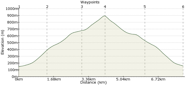
Ascent
754m (2473ft)
Descent
744m (2440ft)
Max. Elevation
900m (2952ft)
Altitude Gain & Loss
1498m (4913ft)
Start & End
Achnasheen
Distance
8.00km
(4.97mi)
(4.97mi)
Duration
~4:30h
Difficulty
Leisurely
Ordnance Survey Map
Fionn Bheinn is one of those lonely Munros that is a day out on its own, rather than part of a group. Not many walkers have much to say about the hill, except that the views across to Torridon are superb, and hey, any day on the hills beats one in the office. So make time to stop off at Achnasheen when travelling between Inverness and Lochalsh. The area is ideal for a wild camp, and there is also a bunkhouse at Ledgowan Lodge in Achnasheen.
Walk Functions
Share
Nearby Walks
Kinlochewe to Lochan Fada
A strenuous, circular walk (riverside) starting in Highlands, Scotland, about 21.50km (13.36 mi) long, duration: ~7:00h.Fuar Tholl, Sgorr Ruadh and Beinn Liath Mhor
A moderate, circular walk (mountain (above 600m)) starting in Highland, Scotland, about 16.00km (9.94 mi) long, duration: ~8:00h.South Torridon Passes
A moderate, linear walk (low hills and fells (below 600m)) starting in Highlands, Scotland, about 12.70km (7.89 mi) long, duration: ~5:00h.Walk Map
- $walk->POI array(0)
Waypoints
OS Grid NH164585
Start at Achnasheen Station, on the Inverness-Lochalsh line.
OS Grid NH156595
Ascend along the rough path by the Allt Achadh na Sine.
About 1.33 km (~0.83 miles) from 
OS Grid NH153611
Head into the corrie beneath Creagan nan Laogh, and onto the summit ridge.
About 1.63 km (~1.01 miles) from 
OS Grid NH148620
Follow the ridge to the summit, which is 933m. It's a simple route home - back the way you came.
About 1.04 km (~0.65 miles) from 
OS Grid NH154603
Return via the river once more.
About 1.83 km (~1.14 miles) from 
 Achnasheen again
OS Grid NH163586
Make sure you're in time to get the train at Achnasheen for more walking adventures to the north, east, south or west.
About 1.85 km (~1.15 miles) from 
