Five village circular walk starting at Barrington
A moderate walk (countryside) in Somerset, England, about 11.90km (7.39 mi) long with an estimated walking time of about 3:30h. It is unsuitable for families with children, prams & pushchairs, wheelchairs.
Elevation Profile
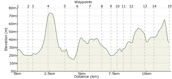
Ascent
66m (216ft)
Descent
69m (226ft)
Max. Elevation
80m (262ft)
Altitude Gain & Loss
135m (442ft)
Start & End
Barrington
Distance
11.90km
(7.39mi)
(7.39mi)
Duration
~3:30h
Difficulty
Moderate
Ordnance Survey Maps
Wonderful five village walk encompassing Barrington, East Lambrook, South Petherton, Compton Durville and Shepton Beauchamp. Best done on a nice summer's day. Parts of the walk can get very muddy, so appropriate footwear is a must.
There are infrequent buses to Barrington, and more regular buses to South Petherton, so you could start and finish the walk there.
Walk Functions
Share
Nearby Walks
Dorset wanderings - Yetminster to Thornford
A leisurely, circular walk (countryside) starting in Dorset, England, about 5.00km (3.11 mi) long, duration: ~1:30h.In the heart of Thomas Hardy's Dorset
A moderate, circular walk (countryside) starting in Dorset, England, about 14.40km (8.95 mi) long, duration: ~4:45h.Glastonbury Tor
A leisurely, circular walk (countryside) starting in Somerset, England, about 5.20km (3.23 mi) long, duration: ~1:45h.Walk Map
- $walk->POI array(0)
Waypoints
OS Grid ST389181
Start the walk in Barrington. Walk east to Water Street towards Barrington Court.
OS Grid ST397180
Take the footpath heading northeast through Barrington Court.
About 0.84 km (~0.52 miles) from 
OS Grid ST398183
Follow the track past a small wooded area.
About 0.35 km (~0.22 miles) from 
OS Grid ST403193
Continue on to Lake Farm.
About 1.12 km (~0.7 miles) from 
OS Grid ST414186
The path joins a road. Turn left then first right to reach West Lambrook.
About 1.27 km (~0.79 miles) from 
OS Grid ST422186
Walk through the orchards to Mid Lambrook.
About 0.81 km (~0.5 miles) from 
OS Grid ST431189
Continue heading east to East Lambrook.
About 0.92 km (~0.57 miles) from 
OS Grid ST429180
Pick up the River Parrett Trail to South Petherton.
About 0.90 km (~0.56 miles) from 
OS Grid ST427175
Continue into South Petherton. There are more bus connections here than Barrington, so you could start and finish here (in the town centre) and still walk the same route.
About 0.61 km (~0.38 miles) from 
OS Grid ST424177
At the end of the Droveway, pick up the path heading west.
About 0.42 km (~0.26 miles) from 
OS Grid ST420175
Follow the path into Compton Durville, which joins Ryddon Lane.
About 0.41 km (~0.25 miles) from 
OS Grid ST417171
From the road just south of the village, look for the path to Shepton Beauchamp.
About 0.53 km (~0.33 miles) from 
OS Grid ST408174
Follow Lambrook Road through the village.
About 0.91 km (~0.57 miles) from 
OS Grid ST402172
Just opposite the church, take the footpath heading north back to Barrington.
About 0.69 km (~0.43 miles) from 
 Barrington again
OS Grid ST393180
Finish up in Barrington. If timed right, there's a bus back to Ilminster (there's one in and out a day).
About 1.22 km (~0.76 miles) from 
