Buck Barrow and Whitfell - the quiet corner of the Lakes
A moderate walk (low hills and fells (below 600m)) in national park Lake District starting and finishing in Cumbria, England, about 17.10km (10.63 mi) long with an estimated walking time of about 6:30h. It is unsuitable for families with children, prams & pushchairs, wheelchairs.
Elevation Profile
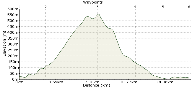
Ascent
543m (1781ft)
Descent
554m (1817ft)
Max. Elevation
560m (1837ft)
Altitude Gain & Loss
1097m (3598ft)
Start
Bootle station
End
Ravenglass station
Distance
17.10km
(10.63mi)
(10.63mi)
Duration
~6:30h
Difficulty
Moderate
Ordnance Survey Map
This walk gives you the chance to enjoy a quiet, unspoilt corner of the Lake District and the rare chance to sit on top of a Lakeland summit on a summer's day and be completely alone. But bear in mind the long walk in and out when planning your train connections.
Walk Functions
Share
Nearby Walks
Muncaster Fell and Glannoventa Fort
A moderate, circular walk (low hills and fells (below 600m)) starting in Cumbria, England, about 14.50km (9.01 mi) long, duration: ~4:15h.Black Combe
A moderate, linear walk (low hills and fells (below 600m)) starting in Cumbria, England, about 11.00km (6.84 mi) long, duration: ~4:45h.Swinside Fell and Stoneside Hill
A moderate, circular walk (low hills and fells (below 600m)) starting in Cumbria, England, about 14.60km (9.07 mi) long, duration: ~5:30h.Walk Map
- $walk->POI array(0)
Waypoints
OS Grid SD094893
Start of the walk. Bootle station is actually in the village of Hycemoor, where you can get a few supplies for the long day ahead.
OS Grid SD119896
Follow the bridleway on the northside of Kilmont Beck, which crosses the moorland road and heads up Corney Fell. Follow the wall around (leaving the bridleway) to the first summit, the rocky top of Buck Barrow. Time for the day's first tea stop.
About 2.51 km (~1.56 miles) from 
OS Grid SD159930
From Buck Barrow, head across the open moor to the second summit of Whitfell. This is open country - no clear paths out here, so you will need to get the compass out. This bit can be tricky in bad weather, as it is a flattish summit with few waymarkers.
About 5.24 km (~3.26 miles) from 
OS Grid SD122937
From the summit of Whitfell, head due west on the bridleway, which takes you down Waberthwaite Fell. Continue down Fell Lane and Lowther Street into the village of Waberthwaite. The Brown Cow inn is well worth a visit if you have time (and if you like real ales, make time!)
About 3.75 km (~2.33 miles) from 
OS Grid SD094940
From Waberthwaite, follow the road to Newbiggin. From here, you can take the Cumbria Coastal Way northeast to cross the river at Hall Waberthwaite, or continue along the road towards Eskmeals Viaduct to cross here at the bridleway.
About 2.73 km (~1.7 miles) from 
 Ravenglass
OS Grid SD085964
Whichever way you choose, follow the CCW into Ravenglass to get the train. The pub on the station - the Ratty Arms - is also good if you missed out in Waberthwaite. A long walk, but a true taste of the Lake District away from the crowds.
About 2.52 km (~1.57 miles) from 
