The Brecon Beacons from the North
A strenuous walk (mountain (above 600m)) in national park Brecon Beacons in Powys, Wales, about 21.30km (13.24 mi) long with an estimated walking time of about 8:15h (1 overnight stay). It is unsuitable for families with children, prams & pushchairs, wheelchairs.
Elevation Profile
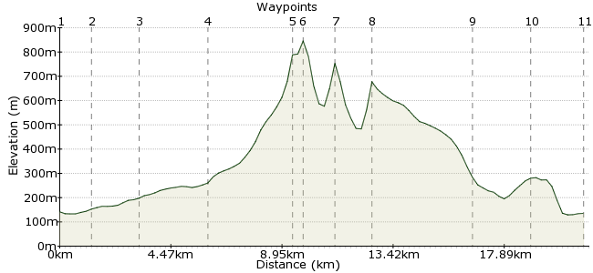
Ascent
708m (2322ft)
Descent
714m (2342ft)
Max. Elevation
850m (2788ft)
Altitude Gain & Loss
1422m (4664ft)
Start & End
Brecon
Distance
21.30km
(13.24mi)
(13.24mi)
Duration
~8:15h
Difficulty
Strenuous
Ordnance Survey Map
The Brecon Beacons National Park gets its name from the four rounded peaks that tower over the town of Brecon - Corn Du, Pen y Fan, Cribyn and Fan y Big. You can complete a circuit of all four from Brecon, making for a long but satisfying day out. There is no rail link to Brecon, but the town is well served by buses. There are several campsites near the town if you are planning a longer stay.
Walk Functions
Share
Nearby Walks
The Brecon Beacons' big three from Storey Arms
A moderate, circular walk (mountain (above 600m)) starting in Powys, Wales, about 15.10km (9.38 mi) long, duration: ~6:30h.Pen Y Fan Horseshoe
A moderate, linear walk (mountain (above 600m)) starting in Powys, Wales, about 16.20km (10.07 mi) long, duration: ~6:15h.Fan Fawr from Storey Arms
A moderate, circular walk (mountain (above 600m)) starting in Powys, Wales, about 19.00km (11.81 mi) long, duration: ~7:15h.Walk Map
- $walk->POI array(0)
Waypoints
OS Grid SO045285
From the town centre, head over the bridge to Llanfaes.
OS Grid SO033279
In Llanfaes, pick up the Taff Trail that heads along Ffrwdgrech Road.. Continue along the road for a couple of kilometres.
About 1.38 km (~0.86 miles) from 
OS Grid SO021264
Stay on the Taff Trail as it leaves the road and heads across the fields. Pass the Penstar bunkhouse and continue along the road for another half kilometre.
About 1.92 km (~1.19 miles) from 
OS Grid SO002247
Right, enough of this road nonsense - this is a car-free walk. At Clwydwaunhir, take the footpath heading South into Cwm Llwch and start the climb to Corn Du.
About 2.54 km (~1.58 miles) from 
OS Grid SO007214
The path is easy to follow, but steep. Keep climbing past Llyn Cwm Llwch, along the Craig Cwm Llwch, to the first summit of the day!
About 3.34 km (~2.08 miles) from 
OS Grid SO012215
The next summit, Pen y Fan, is a short hop to the Northeast. It's also the highest point of the walk at 886m.
About 0.55 km (~0.34 miles) from 
OS Grid SO023213
Next stop Cribyn - follow the Craig Cwn Sere ridge which drops steeply then climbs back up the west flank of Cribyn. You can drop down the Bryn Teg from here to Brecon, but seeing as you're here....
About 1.16 km (~0.72 miles) from 
OS Grid SO036206
...you may as well climb the fourth summit of this fantastic massif. Fan y Big is a short down-and-up via the Bwlch ar y Fan. Now head Northeast along the long shoulder of Cefn Cyff.
About 1.45 km (~0.9 miles) from 
OS Grid SO057241
At Rhiwiau, follow the narrow road North, then take the footpath to Cantrel.
About 4.04 km (~2.51 miles) from 
OS Grid SO053262
Another short section of road, then take the bridleway back into Brecon and head for a well deserved pint!
About 2.14 km (~1.33 miles) from 
 Back to Brecon
OS Grid SO048283
There's lots of good pubs in Brecon if you want a drink, and campsites just outside the town at Brynich Bridge (call 01874 623325) or Bishops Meadow (01874 610000).
About 2.21 km (~1.37 miles) from 
