Pen-y-ghent and Plover Hill
A moderate walk (mountain (above 600m)) in national park Yorkshire Dales in North Yorkshire, England, about 12.20km (7.58 mi) long with an estimated walking time of about 4:45h. It is unsuitable for families with children, prams & pushchairs, wheelchairs.
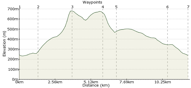
Elevation Profile


Ascent
439m (1440ft)
Descent
445m (1459ft)
Max. Elevation
690m (2263ft)
Altitude Gain & Loss
884m (2899ft)
Start & End
Horton in Ribblesdale
Distance
12.20km
(7.58mi)
(7.58mi)
Duration
~4:45h
Difficulty
Moderate
Ordnance Survey Map
This is one of the many great car-free walks that start and finish at stations on the Settle- Carlisle railway - Horton in Ribblesdale for this walk. Pen-y-ghent is the smallest of Yorkshire's Three Peaks, but add on the side trip to Plover Hill and it's a very satisfying day out. As well as the railway line, you can reach Horton-in-Ribblesdale by Dalesbus www.dalesbus.org
Walk Functions
Share
Nearby Walks
Along the River Ribble
A moderate, walk (riverside) starting in North Yorkshire, England, about 11.50km (7.15 mi) long, duration: ~3:30h.Horton in Ribblesdale to Hawes solo, car free
A strenuous, linear walk (mountain (above 600m)) starting in North Yorkshire, England, about 18.60km (11.56 mi) long, duration: ~6:15h.Horton in Ribblesdale circular walk
A strenuous, circular walk (low hills and fells (below 600m)) starting in North Yorkshire, England, about 23.20km (14.42 mi) long, duration: ~8:30h.Walk Map
- $walk->POI array(0)
Waypoints
OS Grid SD804726
From the station, take in a deep breath of that lovely fresh Yorkshire air. Then, take the road west towards New Inn. Walk past The Crown Hotel (don't worry, we're coming back this way!) and follow the road into Horton Bridge.
OS Grid SD817724
Walk into Brackenbottom and pick up the footpath that cuts straight up Brackenbottom Scar. It's a steep climb, but gets most of the day's legwork over and done with early on.
About 1.31 km (~0.81 miles) from 

OS Grid SD838734
It's an enjoyably steep and scrabbly climb up to the summit of Pen-y-ghent. And you are also now on the Pennine Way, following in the footsteps of thousands of walkers before you.
About 2.32 km (~1.44 miles) from 

OS Grid SD848753
Don't follow the Pennine Way down Pen-y-ghent - instead take the path that leads across the plateau to the north of the summit, and on to Plover Hill.
About 2.14 km (~1.33 miles) from 

OS Grid SD846762
The path continues onto Foxup Moor and meets a bridleway that leads back to Horton in Ribblesdale, as long as you head in the right direction (west).
About 0.92 km (~0.57 miles) from 

OS Grid SD819737
Follow the bridleway across Horton Moor (look our for the grouse butts) and down Horton Scar. The path rejoins the Pennine Way here.
About 3.67 km (~2.28 miles) from 

OS Grid SD808727
Time for a quick pint in the pub before walking back to the station and the train home. Oh go on then, make it two.
About 1.48 km (~0.92 miles) from 

 Horton in Ribblesdale
8 comments... join the discussion!
Gary from the Car Free Walks team
Deciding whether a walk is suitable for children is quite subjective as it depends on their size, physical fitness and previous walking experience. The 'machine' behind the Car Free Walks website tries to do a 'best guess' based on the data it has, then categorises the walk for our search function. Please do post here your own experiences of the route so people can make a judgement for themselves.
Bob Jobsworth
In what way is this walk unsuitable for children?
mac.hawk
Gee, two days later and the 'getdown' link has been removed. Try this one instead http://www.northyorkstravel.info/timetable/11NYCCdec.pdf
Timwoods
Ah, I think that might be my error. The bus is listed on the DalesBus map network, but might not be run by them! www.dalesbus.org
mac.hawk
Unfortunately in 2014/2015 Horton would appear to be unsupported by Dales Bus. As far as I can see the only buses to Horton in the winter 2014/spring 2015, run Tosside-Settle-Horton and return, Mon to Sat - visit http://getdown.org.uk/bus/bus/11-c.shtml.
Mac.Hawk
Just for clarity I'd point out in section (1) that 'New Inn' isn't a pub, it's an area of the village identified on the OS map (rather appropriately where 'The Crown' public house is!!).
Timwoods
Ha, good spot. Will correct it (to coastal walk).
mac.hawk
A circular full day canal walk in England!!!!! Well I know it can be boggy on the top but I doubt you'd get a narrowboat up there!!