Fairfield Horseshoe from Ambleside
A moderate walk (mountain (above 600m)) in national park Lake District in Cumbria, England, about 16.40km (10.19 mi) long with an estimated walking time of about 7:00h. It is unsuitable for families with children, prams & pushchairs, wheelchairs.
Elevation Profile
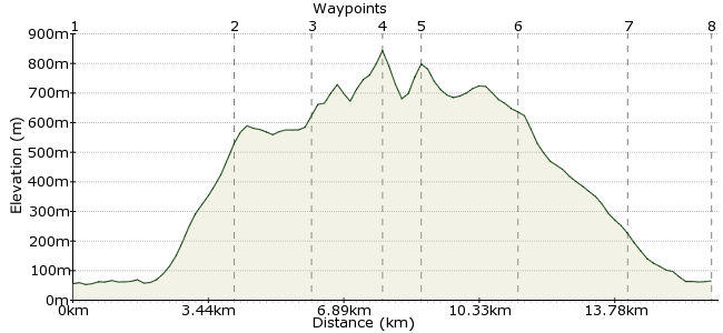
Ascent
788m (2585ft)
Descent
779m (2555ft)
Max. Elevation
850m (2788ft)
Altitude Gain & Loss
1567m (5140ft)
Start & End
Ambleside town centre
Distance
16.40km
(10.19mi)
(10.19mi)
Duration
~7:00h
Difficulty
Moderate
Any regular Lakeland walker can tell you that this is one not to miss. A much-loved classic and deservedly so, the walk around the stunning Fairfield Horshoe from Ambleside should be on everyone's to-do list, even if they have already done it! It's a high-level circuit around the tops of the Fairfield group. Height is gained early, meaning it's an unforgettable day among the clouds - hopefully not too many though, as the view down to Windermere is unbeatable!
Walk Functions
Share
Nearby Walks
Wansfell - the scenic route from Ambleside to Windermere
A leisurely, linear walk (low hills and fells (below 600m)) starting in Cumbria, England, about 8.90km (5.53 mi) long, duration: ~3:45h.Rydal Water and Grasmere
A moderate, linear walk (low hills and fells (below 600m)) starting in Cumbria, England, about 10.80km (6.71 mi) long, duration: ~4:15h.Loughrigg Fell and Lingmoor Fell
A moderate, linear walk (low hills and fells (below 600m)) starting in Cumbria, England, about 13.90km (8.64 mi) long, duration: ~5:30h.Walk Map
- $walk->POI array(0)
Waypoints
OS Grid NY376044
From Ambleside, follow the road up to Rydal (there is also a bus service). In Rydal, there are signposts to the Fairfield Horseshoe. The first section is the steep climb, onto Heron Pike. From here, much of the walk is in land owned by the National Trust.
OS Grid NY355079
Once you start climbing, you will soon be rewarded with great views down towards Windermere.
About 4.11 km (~2.55 miles) from 
OS Grid NY354097
Follow the clear path along the ridge - it's well trodden and easy to find. This is right in the heart of the Lakes - easy to see why people love coming here.
About 1.82 km (~1.13 miles) from 
OS Grid NY359115
Follow the ridge round to Fairfield, the highest point of the walk at 873m. You will need the next map - OL5 - for this bit, but on a clear day, the path round the top of Rydal Head is obvious enough.
About 1.78 km (~1.11 miles) from 
OS Grid NY369111
Route finding is easy - just stick to the high ground! From Dove Crag, the path follows a long shoulder down into Ambleside.
About 1.02 km (~0.63 miles) from 
OS Grid NY374088
Descend along the ridge past High Pike and Low Pike, before the path wiggles its way into Ambleside.
About 2.36 km (~1.47 miles) from 
OS Grid NY375061
Take the final few paces into Ambleside and start thinking about that pint at the end....
About 2.72 km (~1.69 miles) from 
 Ambleside
OS Grid NY376040
Back to Ambleside, which has everything the hungry/thirsty/sleepy walker could need, and then some. It's heaving in summertime, so be warned!
About 2.11 km (~1.31 miles) from 

1 comment... join the discussion!
GaryShipp
The views on this walk are just stunning - take your camera and a thermos!