Dunbar coastal
A leisurely walk (coast) in East Lothian, Scotland, about 6.10km (3.79 mi) long with an estimated walking time of about 1:30h. It is unsuitable for families with children, prams & pushchairs, wheelchairs.
Elevation Profile
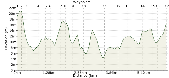
Ascent
31m (101ft)
Descent
33m (108ft)
Max. Elevation
30m (98ft)
Altitude Gain & Loss
64m (209ft)
Start & End
Dunbar
Distance
6.10km
(3.79mi)
(3.79mi)
Duration
~1:30h
Difficulty
Leisurely
Ordnance Survey Map
From the station, walk up the road and turn right. Walking downhill, you can see the sea over the buildings in front of you - the beach is at the bottom of the hill. The sea will now be on your right for most of the walk until Belhaven. Landmarks include harbours, the swimming pool, the Rocks Hotel, a golf course, and Belhaven Bay (first left after going under the railway), rugby/football pitchs (after coming though woods). There are signs for the station after coming back under the railway.
Walk Functions
Share
Nearby Walks
The John Muir Way - Dunbar to North Berwick
A moderate, linear walk (countryside) starting in East Lothian, Scotland, about 19.30km (11.99 mi) long, duration: ~5:45h.North Berwick Law
A leisurely, circular walk (low hills and fells (below 600m)) starting in East Lothian, Scotland, about 2.50km (1.55 mi) long, duration: ~1:00h.Wallyford to Musselburgh
A leisurely, linear walk (countryside) starting in East Lothian, Scotland, about 7.80km (4.85 mi) long, duration: ~2:30h.Walk Map
- $walk->POI array(0)
Waypoints
OS Grid NT680785
Start of the walk
OS Grid NT681786
Walk down the hill to the beach.
About 0.17 km (~0.11 miles) from 
OS Grid NT681787
The beach is down the steps, or walk along the road.
About 0.10 km (~0.06 miles) from 
OS Grid NT680791
Explore the old and new harbours. The Creel and the Volunteer Arms are good for beer and food.
About 0.44 km (~0.27 miles) from 
OS Grid NT678792
The path goes uphill from the castle to the swimming pool.
About 0.23 km (~0.14 miles) from 
OS Grid NT676791
Down the steps, along the cliff top trail, or along the road.
About 0.18 km (~0.11 miles) from 
OS Grid NT673793
The Rocks or Bayswell Hotel for food and beer.
About 0.35 km (~0.22 miles) from 
OS Grid NT674791
Walk past the Bayswell Hotel. Get some food and/or beer.
About 0.14 km (~0.09 miles) from 
OS Grid NT672793
Very wide paved path.
About 0.27 km (~0.17 miles) from 
OS Grid NT668793
Go down the steps following the path around the golf course.
About 0.35 km (~0.22 miles) from 
OS Grid NT662788
Follow the road away from the sea.
About 0.84 km (~0.52 miles) from 
OS Grid NT663784
Keep following the road and go under the railway.
About 0.43 km (~0.27 miles) from 
OS Grid NT666782
Roughly paved farm track into wood.
About 0.31 km (~0.19 miles) from 
OS Grid NT671782
Keep walking roughly east. Keep on the path and straight on at any path junction.
About 0.56 km (~0.35 miles) from 
OS Grid NT675782
Turn left as you leave the woods past the sports pitches.
About 0.40 km (~0.25 miles) from 
OS Grid NT676783
Rail track is to your left.
About 0.16 km (~0.1 miles) from 
 Back under the railway
OS Grid NT679785
Go back under the railway. Turn right and uphill to the station. The Coast Cafe is at the bottom of the hill for food and maybe beer.
About 0.36 km (~0.22 miles) from 
