Ben Vrackie
A leisurely walk (mountain (above 600m)) in Perthshire, Scotland, about 8.70km (5.41 mi) long with an estimated walking time of about 4:30h. It is unsuitable for families with children, prams & pushchairs, wheelchairs.
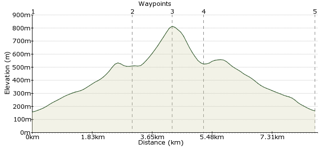
Elevation Profile
Ascent
657m (2155ft)
Descent
648m (2125ft)
Max. Elevation
820m (2690ft)
Altitude Gain & Loss
1305m (4280ft)
Start & End
Moulin
Distance
8.70km
(5.41mi)
(5.41mi)
Duration
~4:30h
Difficulty
Leisurely
Ordnance Survey Map
Heading up to the Cairngorms by train? It's well worth stopping off at Pitlochry for a walk up Ben Vrackie. The hill sits just north of the village of Moulin, which is a short bus ride from Pitlochry. It's an easy walk, and a good warm up for the bigger challenges to the north - my friend Simon recommends it as the perfect hill to test out new winter walking gear! Ben Vrackie's summit is also an excellent viewpoint for many of the hills of central Scotland.
Walk Functions
Share
Nearby Walks
Along the River Garry
A leisurely, linear walk (riverside) starting in Perthshire, Scotland, about 5.50km (3.42 mi) long, duration: ~1:30h.Glen Tilt circular, taking in Carn a 'Chlamain
A strenuous, circular walk (mountain (above 600m)) starting in Perthshire, Scotland, about 26.80km (16.65 mi) long, duration: ~10:15h.Aberfeldy's waterfalls
A leisurely, circular walk (riverside) starting in Perthshire, Scotland, about 3.00km (1.86 mi) long, duration: ~1:15h.Walk Map
- $walk->POI array(0)
Waypoints
OS Grid NN944592
From the bus stop in Moulin, head for the Moulin Hotel. Follow the road uphill behind the hotel, towards a car park (about 300m away). The path to Ben Vrackie is clearly signposted, heading through the trees.
OS Grid NN948622
No complex route directions needed; just use your map and follow the path across the heathland to Loch a' Choire. The path up to the summit is easy to see.
About 3.07 km (~1.91 miles) from 
OS Grid NN953633
The summit, at 841m, is a Corbett, not a Munro. But who cares? It's a glorious hill in the middle of fantastic scenery, so sit down, get your flask out and enjoy the majesty of the Scottish Highlands. There is a marker on the summit to help you pick out hills.
About 1.12 km (~0.7 miles) from 
OS Grid NN946627
There is a path taking a detour around Loch a' Choire, if you fancy a bit of a wander on the way down.
About 0.94 km (~0.58 miles) from 
 Moulin
OS Grid NN943593
Back to Moulin and the bus home. There is a famous salmon ladder in Pitlochry, which is worth a visit - it's just near the dam that forms Loch Faskally. It's hard to spot salmon, but is a lovely place regardless.
About 3.34 km (~2.08 miles) from 
